Jardin des Doms occupies the summit of the Rocher des Doms, a rocky spur on the left bank of the Rhône River in Avignon. More than 30 meters above the river and its valley, it dominates the surrounding landscape and was incorporated into the urban development of the city. The hill is closely linked to Avignon’s earliest history: it is said to have served as a shelter for the city’s founders, and archaeological evidence shows occupation during the Neolithic. Excavations on the hill have uncovered a small anthropomorphic stele, as well as objects including polished green stone axes, jewelry fragments, and pottery shards. The site also has Roman-era associations, when the city was concentrated at the foot of the spur for defensive reasons. Today, the summit is occupied by a public garden.
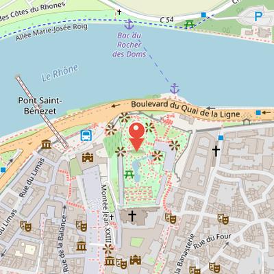
Nearby Objects
-
 Musée du Petit Palais 110 m away
 -
 Notre-Dame-des-Doms 130 m away
 -
 Saint Martial's Chapel 200 m away
 -
 La Cour d'Honneur 200 m away
 -
 Palais des Papes 200 m away
Site and Setting
Jardin des doms is located on a rocky spur on the left bank of the Rhone River. The spur rises more than 30 meters above the river and its valley, giving it a prominent position in the landscape. It was used as a shelter by the founders of Avignon and later became part of the urban development of the city. The summit of the spur is occupied by a public garden, making the site both a historical landmark and a public green space.
Origin of the Name
The name Doms is written without the final -s in Provençal, and it was formerly spelled Domps. Its origin is uncertain, but it may come from the Celtic word Dun, meaning rock, or from Dunum, meaning a fortified height. The name is also linked to the bishop's palace, called domo episcopali, which stood on the slopes of the spur in the Middle Ages. The whole hill took its name from this episcopal palace.
Neolithic Occupation and the Preistoria Stele
Archaeological excavations at rocher des Doms and quartier de la Balance show that the site was occupied during the Neolithic. Among the finds, archaeologist Sylvain Gagniere excavated a small anthropomorphic stele on the hill between 1960 and 1961. The stele is 20 cm high, carved in molasse, and shaped like a funerary stele with an incised stylized human figure without a mouth. A solar representation on the lower right part is considered unique for this type of stele. On the basis of comparisons with other solar representations, the object has been dated between the Copper Age and the Early Bronze Age, corresponding to the southern Chalcolithic. Similar anthropomorphic steles have been found at Lauris, Orgon, Senas, Trets, Goult, and Isle-sur-la-Sorgue in Provence, dated between 2500 and 1800 BCE, and are connected to the Lagoza civilization. Additional discoveries from a large water reservoir at the summit of the rocher include two polished green stone axes, jewelry parts, and many pottery shards, including both indigenous Hallstatt culture and imported Ionic and Phocaean types.
Roman Avignon and the Rocher des Doms
During the Roman period, the city was concentrated at the foot of the spur, where the position offered strong defensive advantages. The forum was located at what is now Place de l'Horloge, while the first nucleus of what would become Avignon Cathedral was established in the 4th century. Roman construction also included a baptistery and the church dedicated to Santo Stefano on the southern slopes. Later, population decline caused by barbarian invasions and epidemics led to a regrouping of inhabitants around the rocher des Doms. The remaining Roman city structures, including the forum, were eventually destroyed.
The Rocher des Doms and the Growth of Avignon
An Arab chronicle dated around 725 presents the Rocher des Doms as the limited core of Avignon in the 8th century, stating that all inhabitants took refuge there. In Medioevo's account, the bishop built a fortified residence on the spur in the 11th century, and the Rocher des Doms became the center of political activity and of the city's revival. The same account describes the rebuilding of the cathedral and the church of Santo Stefano, while also noting that Avignon expanded beyond the double city walls in the 13th century.
Within this historical setting, the cathedral of Notre-Dame des Doms was begun in 1150 on the south part of the Rocher des Doms. Medioevo records that it was first expanded in the 14th century, and that its bell tower collapsed on January 27, 1405, destroying the ancient baptistery. The cathedral was later transformed temporarily into a fortress to house Catalan mercenaries' artillery, and it was completed with lateral chapels in the 17th century. These references place the site at the center of Avignon's religious, political, and defensive history over several centuries.
From Mills to Public Park
In the 16th and 17th centuries, the Rocher des Doms area included cultivated fields, vineyards, and windmills. The I mulini del rocher des Doms were constructed in 1562 to ensure flour production during sieges, and they remained in operation until the mid-18th century. During the 18th century, ramps provided access to the hill, and the site began to be frequented by the people of Avignon. A cemetery was created there in 1802. In the 19th century, the mills were destroyed when gardens were laid out, and by 1830 the entire summit had been converted into a public park.