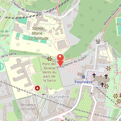
Parc des Hauteurs is an urban park located in Lyon on the hill of Fourvière. It brings together several public places extending from the outskirts of the Basilica of Fourvière to Loyasse cemetery. The ensemble includes Visitation Park and the Passerelle des Quatre-Vents, a viaduct that formed part of the former tramway connection to the cemetery.
The site is linked to the history of access to Loyasse cemetery, created in 1807 on the Sarra plateau at the extreme west of Fourvière hill. A funicular and tramway line were established to serve the cemetery, with trams running 800 meters between the Saint-Paul - Fourvière funicular upper station and Loyasse cemetery. The route used a single platform at the funicular tunnel exit and crossed a valley on an 80-meter-long footbridge. The line operated for five minutes per trip and closed in October 1938.
Urban planning projects for Fourvière were discussed throughout the 20th century, including proposals for parks and gardens. After the 1930 landslide on the east side of the hill, Lyon officials prohibited all construction on the site.
Nearby Objects
-
 Notre-Dame de Fourvière 200 m away
 -
 Chapelle Saint-Thomas 200 m away
 -
 Lugdunum Musée et théâtres romains 250 m away
 -
Conservatoire de Lyon 250 m away
-
 Ancient Theatre of Lyon 350 m away
Layout and Historical Elements
Parc des Hauteurs is an urban park in Lyon on the hill of Fourviere. It brings together several public places extending from the outskirts of the Basilica of Fourviere to the Loyasse cemetery. The park includes Visitation Park and the Passerelle des Quatre-Vents, a viaduct. This structure had a practical transport function: it allowed trams to carry travelers and coffins between the old terminus of the Saint-Paul funicular and the cemetery.
The Fourviere-Loyasse Tramway Link
The site of Parc des Hauteurs is linked to the history of the Loyasse cemetery, which was created in 1807 on the Sarra plateau at the extreme west of the Fourviere hill. To serve the cemetery, a funicular and tramway line was established. The tramway covered 800 meters between the Saint-Paul - Fourviere funicular upper station and Loyasse cemetery. Correspondence between the funicular and the tramways was organized by a single platform at the exit of the funicular tunnel.
The tramway operated on a single track and crossed a valley on an 80-meter-long footbridge. Some tramways were equipped with a hearse trailer, and the route took five minutes to complete. The Saint-Paul funicular service was later interrupted in an unspecified month, and the Fourviere-Loyasse tramway line closed in October 1938.
Planning and Preservation of Parc des Hauteurs
Urban planning documents mentioned a series of different projects for Fourviere hill throughout the 20th century. In 1906, architect Sined proposed creating a park on the hill to address Lyon's shortage of urban parks. His proposal included demolishing the fort and military enclosure, in order to make use of the site's natural beauty. In 1924, Camille Chalumeau planned a circular boulevard as part of Lyon's extension and beautification plan, with the aim of taking advantage of the site's panoramic view.
After the Fourviere disaster in 1930, when unstable balmes caused a landslide on the east side of the hill and killed thirty-nine people, Lyon officials decided to prohibit all construction on the site. Several garden projects were then proposed, including one by architect Giroud. His plan called for a large public garden between Saint-Jean square and the Notre-Dame de Fourviere basilica, linked by a monumental staircase and zigzag paths.
Between 1930 and 1950, the ancient theatre and odeon were cleared, the municipality acquired several lands owned by religious congregations, and an archaeological park was created. Several buildings were also demolished to improve access to the hill, which gradually became a tourist destination. A 1942 city master plan drawn by Lambert was abandoned after the Second World War. Later, Joseph Maillet's 1960 urban planning protected the hill, and Charles Delfante's 1969 master urban plan designated a reserved location for a park, although this project did not succeed. During the same period, the plateau underwent rapid urbanization and large housing projects in the 1960s, while the hill itself remained mostly wooded.
Preservation measures were reinforced over time. The association Renaissance du Vieux-Lyon, created in 1958, achieved protected status for the Saint-Jean district by 1964, and the perspective of Fourviere was no longer to be modified. The Jardin du Rosaire below the basilica was preserved, and almost the entire slope was designated a non-aedificandi zone. Opposition to strict construction regulations appeared in 1979, but the regulations were confirmed in 1982 and revised in 1993.
The 1989 report Parc des Hauteurs by the Lyon urban community's urban planning agency emphasized preservation and enhancement of the Fourviere site. It proposed a pathway linking several attraction centers and connecting monuments and spaces to create a city overlook. The report also called for agreements with landowners to make the pathway public, and noted that some public areas, including Jardin du Rosaire, would undergo extensive development. The agency's study recommended three connected poles: archaeology, religion, and arts, and a study by landscape architect Michel Corajoud was presented as beneficial to the site. The hill's attraction centers include the Gallo-Roman Museum and the Notre-Dame de Fourviere basilica overlooking Vieux-Lyon.
Route and Features of Parc des Hauteurs
Parc des Hauteurs begins at the esplanade de Fourviere, created by engineer Joannees Blanchon between 1880 and 1896, in front of the basilica. It forms a linked route that connects the passerelle des Quatre-vents, the fort, the cimetiere de Loyasse, parc de la Visitation, the archeological park, and the jardin du Rosaire in a complete loop. The belvedere path, designed by landscapers Desvigne and Dalnoky, was the first facility on the site. The route follows the line of the shortest railway line in France, opened in 1900, which linked the funiculaire de Saint-Paul, Fourviere, and cimetiere de Loyasse. Along the way, a viaduct rises 80 meters high and offers views of the colline de la Croix-Rousse and the Monts d'Or. The current passerelle was designed by architect Manuelle Gautrand and engineer Marc Malinowski. At the entrance of the park by montee Nicolas de Lange, remnants of the high station of the funicular are visible. The route also passes alongside a group of houses before reaching piste de la Sarra, where mountain bike descents and tree trails are installed. It then reaches the fort de Loyasse, which remains abandoned despite missions by Guerric Pere and Michel Corajoud in 1994, and extends toward cimetiere de Loyasse, which has been developed since 1807.
The Park of the Visitation
Parc des Hauteurs includes the park of the Visitation, whose alleys follow the former cloister of the Visitandine community. The Visitandine order was created in 1610 by Francois de Sales, bishop of Geneva, and the community settled in Lyon in 1615. Its early religious presence included the monastery of Sainte Marie de Bellecour at the corner of rue Sainte-Helene and rue Francois de Sales, as well as two other monasteries opened at l Antiquaille in 1627 and on the left bank of the Saone in 1640. These monasteries disappeared during the French Revolution.
The nuns reunited in 1809 and settled in La Croix-Rousse in 1839, but the Canuts revolt in 1848 forced them to find another location. In 1850, the community acquired the current land together with the Carmelites community. Architect Pierre Bossan was chosen, in part because his sister, Aimee Bossan, belonged to the community. The foundations were laid in 1854, and the first stone of the monastic church was set in June 1854 in the presence of Cardinal de Bonald. The community occupied the buildings in 1856, and construction was completed in 1858.
In the late 1960s, local authorities purchased the building to create a national architecture school, and the Visitandines moved to Vaugneray. The project was halted by the May 1968 crisis. The Hospices Civils de Lyon then rented the building to house nurses and to create a school for their training. The ground floor was adapted into archive space in 1974, and in 1978 the city of Lyon ceded the building to the Hospices Civils. The Central Archives Service of HCL was created in 1984.
The park itself ends with a small meadow overlooking the south of Presqu ile and a wood above the ancient odeon. From the garden of the Visitation, a narrow path leads to the top of the ancient odeon, then continues between the odeon and the ancient theater by stairs to a Roman road. That road leads to the gates of the archaeological park. Exiting the park leads onto a street turning left, while the door of the Rosary garden lies one hundred meters to the north. The basilica and gardens called jardin du Rosaire were conceived by Pierre Bossan in the second half of the 19th century, reorganized in 1993 by Michel Louis and Ingrid Bourne, and the chapel and garden have been classified as Monuments historiques since 2004.
Botanique in the Jardin du Rosaire
Botanique is situated in the Jardin du Rosaire, below the basilica and slightly to the south. It contains many species of trees, shrubs, and other plants within the park. The site includes many varieties of old roses and euphorbias, giving it a distinct planting composition within Parc des Hauteurs. Among the species identified in the old roses garden are Rosa xanthina f. spontanea, also referred to as Canary Bird, including a specimen in a pergola, as well as Rosa moyesii. The old roses garden also features euphorbia massifs. In the orchard of the Jardin du Rosaire, Wisteria sinensis is present.