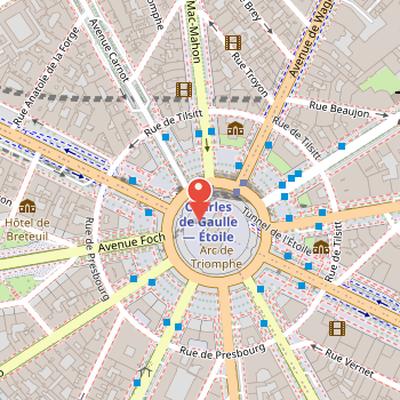
Place Charles-de-Gaulle is a square in Paris centered on the Arc de Triomphe and located at one endpoint of the avenue des Champs-Élysées. Renamed in 1970 from its former name, place de l’Étoile, it is still commonly referred to by that earlier name. The square is shared between the 8th, 16th, and 17th arrondissements of Paris and is served by the Charles de Gaulle-Étoile metro station. Slightly more than one kilometer north of the Seine in western Paris, it is associated with the beaux quartiers area and is considered one of the city’s prestigious locations. The square has a diameter of 241 meters and covers approximately 4.55 hectares, making it the second largest square in Paris after Place de la Concorde. Its surface is decorated paving forming a star, from which twelve straight avenues radiate.
Nearby Objects
-
 Arc de Triomphe 30 m away
 -
 Tomb of the Unknown Soldier 30 m away
 -
 La Marseillaise 40 m away
 -
 Avenue Foch 450 m away
 -
 Le Lido 450 m away
Location and Naming
Place Charles-de-Gaulle is located in Paris and is centered on the Arc de Triomphe. It marks one endpoint of the avenue des Champs-Elysees and is shared between the 8th, 16th, and 17th arrondissements of the city. The place is considered one of the prestigious locations in Paris. It was renamed in 1970 from its former name, place de l'Etoile, although it is still commonly referred to by that older name. The site is served by the Charles de Gaulle-Etoile metro station.
Location and layout
Place Charles-de-Gaulle is located slightly more than one kilometer north of the Seine in western Paris, in an area associated with the beaux quartiers. It is shared between the 8th, 16th, and 17th arrondissements of Paris, together with the Arc de Triomphe. The square has a diameter of 241 meters and covers approximately 4.55 hectares, making it the second largest square in Paris after Place de la Concorde, which covers 8.64 hectares. Its surface is decorated paving arranged in a star pattern.
Radial Layout and Access
Place Charles-de-Gaulle is arranged as a star-shaped junction from which twelve straight avenues radiate. These include Avenue des Champs-Elysees, Avenue de Friedland, Avenue Hoche, Avenue de Wagram, Avenue Mac-Mahon, Avenue Carnot, Avenue de la Grande-Armee, Avenue Foch, Avenue Victor-Hugo, Avenue Kleber, Avenue d'Iena, and Avenue Marceau. Several of these avenues have had earlier names, such as Avenue de Friedland, formerly Boulevard Beaujon; Avenue Hoche, formerly Avenue de la Reine-Hortense and Boulevard Monceau; Avenue de Wagram, formerly Boulevard de l'Etoile and Boulevard Bezons; Avenue Mac-Mahon, formerly Avenue du Prince-Jerome; Avenue Carnot, formerly Avenue d'Essling; Avenue de la Grande-Armee, formerly Avenue de Neuilly; Avenue Foch, formerly Avenue du Bois (de Boulogne) and Avenue de l'Imperatrice; Avenue Victor-Hugo, formerly Avenue d'Eylau and Avenue de Saint-Cloud; Avenue Kleber, formerly Avenue du Roi-de-Rome and Boulevard de Passy; and Avenue Marceau, formerly Avenue Josephine.
The twelve avenues form six axes. One of these is the historical axis of Paris, made up of Avenue des Champs-Elysees and Avenue de la Grande-Armee, and extending from Palais du Louvre to Arche de la Defense and beyond. The other axes are Avenue de Friedland and Avenue Foch; Avenue Hoche and Avenue Victor-Hugo; Avenue de Wagram and Avenue Kleber; Avenue Mac-Mahon and Avenue d'Iena; and Avenue Carnot and Avenue Marceau.
The place is also framed by two circular streets, Rue de Presbourg and Rue de Tilsitt, both named in 1864 after two diplomatic successes of Napoleon. Rue Lauriston lies between Avenue Kleber and Avenue Victor-Hugo and radiates around the place, ending at Rue de Presbourg without disrupting the harmony of the site.
Below the surface, the place is crossed by several transport routes. Tunnel de l'Etoile under the square was closed to traffic in 2015, but it had previously allowed direct passage from Avenue des Champs-Elysees to Avenue de la Grande-Armee. Passage du Souvenir is an underground pedestrian passage that connects the Arc de Triomphe plaza to the sidewalks of Avenue des Champs-Elysees and Avenue de la Grande-Armee. The site is also crossed underground by RER A at Gare de Charles-de-Gaulle - Etoile, and by Metro lines 1, 2, and 6. Place Charles-de-Gaulle is served by Charles de Gaulle - Etoile station.
From Hilltop Boundary to Monumental Square
Place Charles-de-Gaulle was created around 1670 at the top of the former witness hill of the northern part of Chaillot hill. From 1730, the hill was known as Butte de l'Etoile because of the intersecting alleys that formed a star shape. Between 1768 and 1774, Jean-Rodolphe Perronet, acting on a proposal by the royal buildings inspector Ange Gabriel, cut down the hill. The earth removed was used to fill the Champs-Elysees and to form the slopes of the present rues Balzac and Washington. In 1787, the wall of the Fermiers generaux bypassed the place on the east and included the Barriere de l'Etoile, designed by Claude-Nicolas Ledoux to collect octroi at the entrance to Paris. This barrier, also called Barriere de Neuilly or Barriere des Champs-Elysees, was flanked by two buildings that have since disappeared.
At the end of the 18th century, the place marked the boundary between Passy and Neuilly, and it remained a very sparsely built area around 1800. At the beginning of the 19th century, the star was limited to the intersection of the Champs-Elysees and avenue de Neuilly, now avenue de la Grande-Armee, with the outer boulevards at the octroi wall. The construction of a triumphal arch at the center of the place began in 1806 by order of Napoleon Bonaparte and was completed in 1836 under Louis-Philippe. In the second quarter of the 19th century, the star was partly reshaped by avenues such as Saint-Cloud, Muette, and rue du Bel Air, while new roads appeared with the urbanization of the Ternes and Beaujon districts.
The site also hosted the Hippodrome from 1845 to 1855, on the former location of the military orphans' school building begun in 1787. The space later freed by the abandonment of that building helped shape the area between current avenue Kleber and rue Dumont-d'Urville. Under the Second Empire, the major avenues around the square were completed and the square was redesigned by architect Jacques Hittorff. A decree of April 23, 1854 allotted space around the Arc on part of a Chaillot promenade for private mansions that still exist, with colonnaded facades facing the square. These buildings, arranged around a courtyard open to the circular streets now called rues de Tilsitt and de Presbourg, were nicknamed the hotels des Marechaux by Parisians.
Naming and Renaming
The square was originally known as place de l'Etoile, a name referring to the star-shaped street configuration at the site. The term etoile is commonly used for similar urban layouts, including the rond-point de l'Etoile in Ixelles, Belgium. After the death of Charles de Gaulle in retirement at Colombey les Deux Eglises, the name was officially changed by order to place Charles de Gaulle. The avenue des Champs-Elysees had first been considered for renaming, but the square was chosen because it had no residences or shops.
The change did not end disagreement. It remained controversial in relation to Charles de Gaulle's resignation after the referendum of 27 April 1969, and this led to the creation of the Comite national de defense de la place de l'Etoile - Sanctuaire du Soldat Inconnu et du Prestige de Paris, directed by Paul Antier. The committee sought to preserve the original name.
The renaming also influenced later municipal practice. Since then, Paris Council rules have prohibited naming public ways after people who died less than five years earlier, although exceptions exist, such as place Jean-Paul-II in 2006. These rules were intended to avoid disturbing established habits, as illustrated by the later addition of Marcel Dassault to the name rond-point des Champs-Elysees-Marcel-Dassault. For practical reasons, RATP also renamed the Etoile metro station Charles de Gaulle - Etoile to reduce confusion for tourists heading to Paris-Charles-de-Gaulle airport. A small rue de l'Etoile still remains near the square.
Celebrations and Historic Events
Bâtiments remarquables et lieux de mémoire presents Place de l'Etoile, now Place Charles-de-Gaulle, as a site associated with celebrations and major public events. The record includes a fireworks display on 14 July 1801, as well as the Fete de la Fraternite in 1848 at the Barriere de l'Etoile. It also depicts the imperial procession marking the entry of Napoleon and Marie-Louise, the entry of Napoleon III into Paris, and the return of Napoleon's ashes. In addition, a plaque at 156 avenue des Champs-Elysees commemorates the demonstration of 11 November 1940, linking the area to later acts of remembrance.