Place d’Italie is a square in Paris situated at the meeting point of several boulevards, avenues, and streets, and served by metro lines 5, 6, and 7 at the Place d’Italie station. Its centre is occupied by the Jardin Françoise-Giroud, while the esplanade along the Italie 2 shopping center was named place Henri-Langlois in 1995. Historically, the site lies at a bifurcation between the ancient Roman road from Lutèce to Lugdunum and the route de Fontainebleau, also known as avenue d’Italie. Avenue de Choisy traces the ancient Roman road, and the area is linked to the development of several southern Paris roads and boulevards over time. In 1784, boulevard de l’Hôpital and boulevard des Gobelins became part of the mur des Fermiers généraux, and two symmetrical octroi pavilions designed by Claude-Nicolas Ledoux were built at the barrière d’Italie. The site marked the border between Paris and the communes of Gentilly and Ivry until 1860.
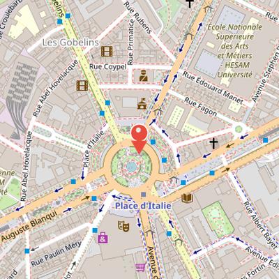
Nearby Objects
-
 Pitié-Salpêtrière Hospital 900 m away
 -
 Église Saint-Médard 1000 m away
 -
 Galerie de Paléontologie et d'Anatomie comparée 1100 m away
 -
 Muséum national d'histoire naturelle 1200 m away
 -
 Val-de-Grâce 1200 m away
Layout and Access
Place d'Italie is located at the meeting point of several streets and avenues in Paris, including boulevards Vincent-Auriol, de l'Hopital, and Auguste-Blanqui, as well as avenues des Gobelins, de la Sueur-Rosalie, d'Italie, and de Choisy, and the streets Bobillot and Godefroy. The center of the site is occupied by the Jardin Francoise-Giroud. Along the Italie 2 shopping center, the esplanade was named place Henri-Langlois in 1995. The area is served by metro lines 5, 6, and 7 through the Place d'Italie station.
Historic Road Junction and Urban Expansion
Place d'Italie is located at a junction shaped by two long historical routes: the ancient Roman road from Lutecia to Lugdunum and the route de Fontainebleau, later known as avenue d'Italie. The Roman road left Paris via rue Mouffetard and followed the itinerary that would later correspond to the future nationale 7. Avenue de Choisy traces this ancient line, while the route de Fontainebleau was developed under Francois.
The area appears in several stages of planned urban development. Turgot's 1739 plan shows a broad tree-lined road beyond rue Mouffetard, near rue du Petit-Gentilly and rue Veronese, climbing the slope of the butte aux Cailles and widening into a semicircle near the windmill of the petite pointe Saint-Marcel. That windmill was removed around 1760 to make way for the place. In 1740, the Paris city bureau decided to pave and plant trees along a path linking the Seine to the Choisy and Fontainebleau roads; this path does not appear on plans before that date.
The wider southern axis continued to evolve with the construction of boulevard des Gobelins, now boulevard Auguste-Blanqui, during the 1760s as part of the boulevard du Midi project. This boulevard was also called boulevard d'Italie. The project itself had begun at the end of the 17th century and was revived by an arrêt in 1763. Nearby, boulevard de l'Hopital appears on Delagrive's later plan as the fourth branch of the etoile.
In 1784, boulevard de l'Hopital and boulevard des Gobelins became part of the mur des Fermiers generaux, bordered the southern boulevards, and were doubled by outer belt boulevards. At barriere d'Italie, two symmetrical octroi pavilions designed by Claude-Nicolas Ledoux were built; they were burned in 1789 and later repaired. The barriere d'Italie marked the border between Paris and the communes of Gentilly and Ivry until 1860. In 1818, after the extension of the Fermiers generaux wall, a sixth branch of the etoile was created, forming boulevard interieur de la gare, now boulevard Vincent-Auriol, and including the village des Deux-Moulins south of La Salpetriere.
History and Urban Form
The history of Place d'Italie is closely linked to changes in the surrounding city fabric. General Brea was arrested on June 25, 1848 at the Fontainebleau barrier by insurgents and executed near the current Avenue d'Italie. In 1860, the area between the Fermiers generaux enclosure and the Thiers enclosure was annexed to Paris, and the octroi barriers were moved while the wall was removed to create a boulevard belt. The town hall of the new district was first installed in one of the octroi pavilions.
The square also reflects the political events of the Commune de Paris. It was renamed Place Emile-Duval on the proposal of Leo Frankel, in honor of Emile Duval, who was shot at Petit-Clamart. After the insurrection ended, the name Place d'Italie was restored. In 1877, the Ledoux pavilions were destroyed to widen the square and make room for a new town hall.
Its present shape remains that of a large round square, but it lacks the regularity and size of Place de l'Etoile and Place du Trone because of the topography.
Urban Changes and Episodes of Violence
Place d'Italie was marked by damage during a German air raid on January 30, 1918, during World War I. In the 1960s, the area became part of the Italie 13 project, which aimed to create a district of towers along Avenue d'Italie. As part of this plan, six towers of about 30 floors were started near Place d'Italie. Most of the project was cancelled in 1975. The planned Apogee tower was replaced by a multicolored mast, or campanile, designed by architect Kenzo Tange. In 1992, the campanile site was replaced by offices, a hotel residence, shops, and the former audiovisual complex Grand Ecran Italie. The square was again affected by violence during a Gilets jaunes protest on November 17, 2019, when urban furniture, shop windows, and the stele near Marshal Juin's statue were damaged. In December 2019, a vandal was convicted to prison and ordered to pay repair costs for damage to the stele.
Place d'Italie in the 13th Arrondissement
The heart of the 13th arrondissement is largely centered on place d'Italie, except for the Paris Rive Gauche neighborhood along the Seine. It includes the main neighborhoods of Gobelins, the quartier asiatique, and Butte-aux-Cailles. Place d'Italie functions as a mandatory passage for car traffic and for most metro and bus lines, making it an important transit area between the suburbs and central Paris, and also between Montparnasse and the right bank. The area borders one of the largest shopping centers in Paris and includes nightlife venues such as restaurants and cinemas on avenue des Gobelins. Place d'Italie was also home to the Gaumont Grand Ecran Italie cinema, which had the largest 35 mm screen in Paris.