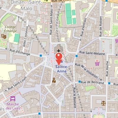
Place Sainte-Anne is a square in the French commune of Rennes, located north of the historic center in the Centre district. It is near Basilica Saint-Aubin in Notre-Dame-de-Bonne-Nouvelle to the north, and near the Jacobins convent and the tourism office to the west. The square includes a carousel on its west side, a book market in its central part, and restaurants. It is served by Sainte-Anne metro station on lines A and B, and can be reached from several surrounding streets, including contour Saint-Aubin, rue de Saint-Malo, rue de la Motte-Fablet, rue d'Échange, rue Pont-aux-Foulons, rue Penhoët, rue Saint-Michel, and rue Saint-Louis. Place Sainte-Anne is also close to the Visitation shopping center and to rue Saint-Michel, known as rue de la Soif. Archaeological excavations carried out by Inrap in 2013 revealed a long history on the site, including Gallo-Roman occupation, a first Augustan construction, later urbanization, a glassmaker's workshop, and a domus. In the Middle Ages, the site lay outside the town near the north ramparts of Rennes, and later became associated with the cemetery of Saint-Aubin parish and the nearby Couvent des Jacobins.
Nearby Objects
-
 Basilique Notre-Dame de Bonne Nouvelle 60 m away
 -
 Couvent des Jacobins 120 m away
 -
 Maison du Peuple de Rennes 140 m away
 -
 Place du Champ-Jacquet 150 m away
 -
 Place des Lices 300 m away
Location in Rennes
Place Sainte-Anne is a street in the French commune of Rennes. The available information identifies it by its location, placing it within the urban fabric of Rennes in France.
Location and Uses of Place Sainte-Anne
Place Sainte-Anne is located north of the historic center of Rennes, in the Centre district. It is near Basilica Saint-Aubin in Notre-Dame-de-Bonne-Nouvelle to the north, and close to the Jacobins convent and the tourism office to the west. The square is served by Sainte-Anne metro station on lines A and B, and it can be reached from several surrounding streets, including contour Saint-Aubin and rue de Saint-Malo to the north, rue de la Motte-Fablet and rue d'Echange to the east, and rue Pont-aux-Foulons, rue Penhoet, and rue Saint-Michel to the south. It is also close to the Visitation shopping center and to rue Saint-Michel, known as rue de la Soif. The square includes a carousel on its west side, a book market in its central part, and restaurants. These elements make Place Sainte-Anne a busy public space with both transit access and local activity.
Archaeological History of Place Sainte-Anne
Several excavations by Inrap were carried out in 2013 during metro construction and the redevelopment of the Jacobins. The investigations showed that, in Gallo-Roman antiquity, the site of Condate at Place Sainte-Anne lay at the intersection of a decumanus and a cardo maximus. The remains include a first Augustan construction dating from before the Common Era, followed by a new phase of urbanization in the 1st century AD. Archaeologists also identified portico galleries and various earth-and-wood constructions. Among the finds were a glassmaker's workshop from the 1st century AD and a significant domus dating to the 4th and 5th centuries.
Historical Changes at Place Sainte-Anne
Place Sainte-Anne has a long history tied to the development of Rennes. In the Middle Ages, it lay outside the town, north of the ramparts, near the Saint-Michel gate and the Foulons gate. Historical accounts describe it as a populated suburb with houses, cellars, and gardens, and they also record the cemetery of the Saint-Aubin parish there. A temple stood on the site that is now occupied by the Couvent des Jacobins, which was founded nearby with support from Jean IV of Brittany. The place is also linked to a meeting in 1491, when Duchess Anne of Brittany met her future husband, King Charles VIII, there.
By the 16th century, the site changed again: in 1557, the hospital was transferred to Saint-Yves hospital, leaving only the chapel. The square was renamed Place des Jeunes Malouins in 1792, in reference to youth aid from Saint-Malo in January 1789. In the 19th century, Jean Leperdrit, later mayor of Rennes in 1794 and 1795, lived in the house at the corner of Place Sainte-Anne and Rue des Changes. Paul Feval described the square in 1852 as a large muddy trapeze surrounded by shabby hovels.
The west part of the current square was occupied by the old Saint-Aubin church until 1904, while the new church was constructed from 1884 and was frequented by Marcel Callo. In more recent history, Place Sainte-Anne remained a large parking lot until 2002. The parking area was then removed and replaced by a pedestrian square during construction of metro line a, and further modifications followed with the construction of metro line b in the 2010s.