Boulevard de Magenta is a boulevard in the 10th arrondissement of Paris, situated across the Saint-Vincent-de-Paul, Porte-Saint-Denis, and Porte-Saint-Martin quarters. It begins at Place de la République and 1, rue Beaurepaire, and ends at 1, boulevard Marguerite-de-Rochechouart and 53, boulevard de la Chapelle. The boulevard forms a connection between the south-east and north-west extremities of the area.
The name of the boulevard comes from the Battle of Magenta. According to the historical note provided, Napoléon III won this battle during the Italian campaign in Lombardy against Austrian troops. A station named after the boulevard is located east of Gare du Nord and is served by the RER line under the name Magenta, though it is not located under boulevard de Magenta itself. The boulevard’s history is linked to earlier street-cutting and planning ordinances concerning the surrounding district and nearby roads.
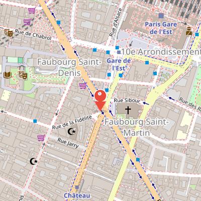
Nearby Objects
-
 Saint-Laurent 80 m away
 -
 Théâtre Antoine 500 m away
 -
 Saint-Vincent-de-Paul Church 600 m away
 -
 Porte Saint-Martin 650 m away
 -
 Théâtre de la Porte Saint-Martin 650 m away
Situation and Access
Boulevard de Magenta is located in the 10th arrondissement of Paris, within the quartiers of Saint-Vincent-de-Paul, Porte-Saint-Denis, and Porte-Saint-Martin. It begins at place de la Republique and 1, rue Beaurepaire, and ends at 1, boulevard Marguerite-de-Rochechouart and 53, boulevard de la Chapelle. The boulevard connects the south-east and north-west extremities of the area, making it a link across this part of the district.
A station named after the boulevard is located east of Gare du Nord and is served by the RER line under the name Magenta. However, the station Magenta is not located under boulevard de Magenta.
Name Origin
The boulevard de Magenta takes its name from the Battle of Magenta. This reference reflects a historical connection to the military victory associated with Napoleon III, who won the Battle of Magenta during the Italian campaign in Lombardy against Austrian troops. The boulevard name therefore preserves a memory of that event through the urban landscape.
Origins and renaming of the street
The street was created through a series of official acts linked to the development of the Poissonniere district in Paris. A royal ordinance authorized the opening of a street on lands owned by Andre and Collier, and another ordinance authorized the cutting of a street starting from rue des Magasins toward the barrier Poissonnierre. The historical record also cites letters patent dated April 10, 1783, as well as the deliberation of the General Council of the Seine department acting as the Paris Municipal Council, the opinion of the prefect of the Seine department, and a certificate from the mayor of the third arrondissement confirming publication of the plan in accordance with regulations.
The street was originally named rue de la Barriere-Poissonnierre because it led to the barrier Poissonnierre. In 1833, it was renamed rue du Nord. The same historical documentation also refers to the royal ordinance authorizing the formation of rue Lafayette and place Charles-X, the plan of several other streets and squares connected to the new Poissonnierre district, and the royal ordinance allowing the city to acquire land from Andre and Collier for the new Saint-Vincent-de-Paul church. One order further states that Andre and Cottier were authorized to open streets under specified numbers on their lands in Paris.
Street Layout and Planning Around Boulevard de Magenta
Historical planning documents define boulevard de Magenta in relation to a set of adjoining streets and open spaces. It is identified as running from rue de Dunkerque at its junction with avenue de Denain toward the barriere Poissonniere. The same records describe avenue de Denain as extending from the triangular crossroads of rue Charles-X and Place Lafayette toward the barriere Saint-Denis, while rue de Dunkerque runs from rue du Faubourg-Poissonniere to faubourg Saint-Martin and cuts rue Lafayette and other streets.
The plan also establishes several connecting streets around the boulevard. Rue des Petits-Hotels is recorded from place Charles-X and rue de Dunkerque to its junction with rue Lafayette, rue de Saint-Quentin from rue de Chabrol to rue Charles-X, and rue de Rocroy as a transverse street linking boulevard Magenta and rue de Belzunce. Rue d'Abbeville and rue de Valenciennes are both described as starting from the area of place Charles-X, one toward rue du Faubourg-Poissonniere and the other toward faubourg Saint-Denis. Rue de Belzunce is noted as running from rue Lafayette parallel to the rear of Saint-Vincent-de-Paul church, with a prohibition against the church perron and steps protruding onto its alignment.
The documentation sets precise widths for the new streets and squares. Boulevard Magenta, avenue de Denain, rue des Petits-Hotels, rue de Saint-Quentin, rue de Belzunce, rue de Rocroy, and rue d'Abbeville are each assigned a width of twelve meters. Rue de Dunkerque is to be ten meters wide, rue Lafayette twelve meters from rue de Dunkerque to rue Charles-X and thirteen meters beyond, and Place Lafayette fifteen meters wide. The church area is also treated as a reserved free space, opening on one side to rue des Petits-Hotels and on the other to place Charles-X with stairs. A rectangular square is ordered at the junction of rue Lafayette, boulevard Magenta, and the extension of rue d'Hauteville.
Street Formation and Public Works Conditions
The available record describes a set of administrative measures linked to the enlargement of place Charles-X and the formation of new streets and squares. Historique ordered the enlargement of place Charles-X to the area shown in yellow and authorized the creation of streets and squares under conditions imposed on Compagnie Andre and Cottier. The company was required to give up, without payment, the land occupied by the streets, except in the case of the place Charles-X enlargement. It also had to bear the cost of the initial paving, lighting, and drainage of the streets, and to install hard stone sidewalks on both sides according to the dimensions fixed by the Administration. Street portions without openings were to be closed with gates or other means until the adjoining property owners consented. The company was further required to comply with the laws and regulations governing Paris public roads. In addition, Historique authorized the Seine prefect to acquire the city block at the intersection of rue Charles-X, rue de la Chapelle, and rue du Chateau-Landon, and ordered that this block be integrated into the public roads. The Interior Minister was assigned to execute the ordinance.
Haussmannian Planning and Social Change
Boulevard de Magenta was developed as part of a Haussmannian urban project. In 1855, the cutting of a 27 meter wide boulevard du Nord between faubourg Saint-Martin and barriere Poissonniere was declared a public utility. Work began immediately at the right corner of rue de la Douane and the right corner of rue de la Fidelite under baron Haussmann. A convention between the Ville de Paris and the State was signed in 1858 for the extension of boulevard du Nord between Chateau d'eau, and the project was confirmed by decree and again declared of public utility in 1859. In 1864, the section between boulevard de Strasbourg and Chateau d'eau still remained to be constructed. The right side of rue du Nord remains preserved, according to Historique. Later, boulevard Magenta became the main access to gare du Nord and was lined with Haussmannian buildings that attracted an affluent population. Over time, however, the bourgeoisie began to move away from the boulevard because of traffic and the presence of new factories near the stations. Its popular image was also reflected in a 1916 Vincent Scotto song mentioning the boulevard.
Traffic Changes and Cycling Conditions
Boulevard de Magenta was transformed into a red axis in the 1980s, with parking forbidden in order to increase the number of traffic lanes. Around the turn of the millennium, under deputy mayor Charlotte Nenner, the roadway was inaugurated as a four-lane street with narrow sidewalks. By 2009, it was considered the second most accident-prone Parisian axis, with accidents reported at rue du Chateau d'eau and rue de Lancry.
From the 2010s, the bike lane was widely criticized. Cyclists found it uncomfortable because of collision risks with pedestrians along the entire route, and its width did not allow overtaking. Its proximity to parking also created the risk of passenger door collisions. These conditions led to dissatisfaction among cyclists and many conflicts with pedestrians. In 2020, the only improvement was that the bike lane was highlighted with green resin, but cycling associations considered this insufficient and asked for the boulevard to become one-way in order to create wider bike lanes.
Notable Buildings and Decorative Details
Boulevar de Magenta includes several buildings listed in Bâtiments remarquables et lieux de mémoire for their architectural details and historical associations. At 5 Boulevard de Magenta, a sculpted porch by Francois Theophile Murgey is noted. The building at 11 Boulevard de Magenta features allegories representing Science and Industry, while 19 Boulevard de Magenta is distinguished by a door frame with lion heads and a mascaron above the second-floor windows. At 22 Boulevard de Magenta, the building suffered damage from an explosion at restaurant Very. Further along the boulevard, 50 Boulevard de Magenta has carved window frames on the second floor by Charles Gauthier, and 52 Boulevard de Magenta has carved framing around the oculus above the entrance door. The building at 56 Boulevard de Magenta is marked by atlantes supporting the second-floor balcony; it was built in 1866 on the former French garden property of Pierre Etienne Bougeois, marquis de Boynes, and later bought at auction by Jean Honore Dubail, a baker and uncle of the future mayor of the arrondissement. This address also housed the workshop of inventor Albert Hirt, creator of the rotary pump on a wheelbarrow, and was home to several residents including Majer Rozenblat, a foreign Jewish volunteer in the French army, actress Alice Dufrene, and Denise Dinten, a lawyer and mistress of a German spy prosecuted for collaboration. The same source also notes the facade south of Saint-Laurent church adjoining Saint-Laurent square, and Boulevard de Magenta near Alban-Satragne square.
Popular Culture References
Boulevard de Magenta is described by Jules Claretie in Le Train 17, published in 1877, where it is associated with the boulevard's ambiance and activities during the early Third Republic. It also appears in the song Khouk Travolta by Mohamed Maazouni, including the lyric Khouk Travolta ou saken boulevard Magenta. These references show the boulevard's presence in literary and musical works.