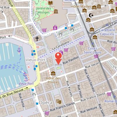
Place du Général-de-Gaulle is a square in Marseille located at the intersection of la Canebière and rue Paradis, facing the Palais de la Bourse. The square is named after Charles de Gaulle, the French military officer, resistant, statesman, and writer who lived from 1890 to 1970.
The site has a long history. A first project dates from 1725, and the square was realized around 1778 after the demolition of the arsenal des galères. Preventive archaeological excavations carried out during its construction provided information on the site’s early occupation and urban development. The area had earlier been occupied by a marsh since the Bronze Age, later drained around the Roman period. Roman remains included a paved platform bordered by a canal, probably used as an unloading area for ships, as well as a beach area that was later abandoned due to silting and replaced by salt pans. The sector was further urbanized through a road and a hydraulic network linked to the medieval fortifications of Marseille.
Nearby Objects
-
 Église Saint-Ferréol les Augustins 200 m away
 -
 Opéra de Marseille 200 m away
 -
 Hôtel Louvre et Paix 300 m away
 -
 Musée d'Histoire de Marseille 300 m away
 -
 Jardin des Vestiges 300 m away
Location and Development
Place du General de Gaulle is located at the intersection of la Canebiere and rue Paradis, facing the palais de la Bourse. The first project for the site dates from 1725, and it was realized around 1778 after the demolition of the arsenal des galeres. Its construction included preventive archaeological excavations, which provided data on the site s primitive occupation and urban development. In 1993, an underground parking facility with 520 places was built there.
Name and Dedication
Place du General-de-Gaulle is named after Charles de Gaulle. Charles de Gaulle was a French military officer, resistant, statesman, and writer, and he lived from 1890 to 1970. The name of the place therefore reflects a commemoration of an important public figure whose career combined military service, political leadership, and literary activity.
Roman-Era Transformation of the Site
Historical records indicate that a marsh existed at this location from the Bronze Age. It was drained around the Roman period, when a paved platform bordered by a canal was also present. This platform probably served as an unloading area for ships. In Roman times, the port shore was located east of the current quai des Belges, while a beach to the west of the platform was abandoned because of silting. By the end of the 1st century AD, this beach area had been replaced by salt pans, and from the beginning of the 2nd century AD, the salt marshes were in turn drained.
Medieval Routes and Urban Growth
At the end of the 12th century, Marseille had a double fortification in its southern part, with the inner wall built around 1190. This wall opened through a gate called La Calade, located on rue de la reine Elisabeth near place Gabriel Peri. Remains of a road corresponding to this gate were found at place du General-de-Gaulle. This route served the Huveaune valley, la Garde hill, and Saint-Victor.
Along the rampart, a surface water collection system was also built. The water channel was known as the ruisseau des cuiratiers. Together, this hydraulic network and the communication route enabled the urbanization of the sector. Foundations of the Saint-Sepulcre hospital were identified along the road. Founded at the end of the 12th century, it was intended to receive and care for pilgrims to Jerusalem. A new building was constructed there in the mid-13th century, but the hospital declined and was abandoned around 1280.
In the 14th century, residential blocks were built and formed the faubourg Sainte-Catherine, which was destroyed in 1360. A municipal council resolution later decided to create an opening between rue Paradis and la Canebiere.
Early History of the Square
The square was created after 1784, following the demolition of the grand pavilion of the galley arsenal. Its creation had faced opposition because of a project for an annonerie and because of financial difficulties in acquiring the land. In its original form, the square was smaller, and its southern section included houses and a concert hall. The concert hall was later destroyed by order of the representatives of the people in mission, by decree, because it had been used by a section of the Marseilles federates. Similar destruction was carried out against other monuments, including the abbey of Saint-Victor. The demolition weakened the nearby houses, which were then removed for reasons of public safety. In 1802, the land was returned to its former owners, and a ballroom called Vauxhal or Wauxhall was opened there. This ballroom was reportedly poorly frequented and had a pointed roof known as the pavillon chinois or lou pounchu.
Historical Names of Place du General-de-Gaulle
The square now known as place du General-de-Gaulle has undergone a long series of name changes that reflect successive political and local shifts. It was originally called place de la Paille, a name linked to its use as a mule park behind the galley arsenal. In 1789 it became place Necker, after the minister born in Geneva, then place de la Liberte in 1793. In 1802 it was renamed place aux Fruits because an fruit and vegetable market had been installed there. The square was called place Imperiale from 1803 to 1814, then place Royale in 1814. Later names included place de la Republique in 1848, place de la Tour in 1857 in honor of de la Tour de Glene, and place la Revolution in 1870. From 1870 to 1970 it was known as place de la Bourse. It was later renamed after General de Gaulle following a municipal council resolution.
Decorative Features and the Hôtel des Princes
Place du General-de-Gaulle has been repeatedly redecorated over time. According to Batissements remarquables et lieux de memoire, the square was first decorated in 1778 with a fountain created by Fossati, which was transferred in 1825 to the Place des Capucines. It was later adorned by a statue of Pierre Puget sculpted by Henri-Edoard Lombard, then by the bear trainer sculpture by Louis Botinelly, now located on the Esplanade de la Tourette. A modern fountain now decorates the square after the creation of the parking lot.
The site is also marked by a notable building built in 1786 to replace the demolished arsenal of galleys. This building was named the Hotel des Princes in 1818. It served as Bonaparte's headquarters on the 22nd and on another date when he took command of the Italian army. Its first floor has an iron balcony supported by two siren-shaped caryatids, described as unique in Marseille.