Morand Bridge crosses the Rhône River in Lyon and links the 1st and 6th arrondissements. The current structure was built during the construction of Lyon Metro Line A, which it carries in its deck. It replaces four earlier bridges that stood at the same location.
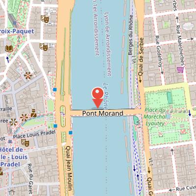
The bridge occupies a notable position in the city’s riverfront layout. On the west side, it opens onto place Louis-Pradel next to place Tolozan and marks the beginning of the Presqu’île, the center of Lyon. It also forms the boundary between quai Jean-Moulin to the south and quai André-Lassagne to the north. On the east side, it opens onto place du Maréchal-Lyautey and reaches the intersection of quai de Serbie to the north and quai du Général-Sarrail to the south.
The first wooden bridge was built in 1774 by urban architect Jean-Antoine Morand. It later became known under several names before taking the name pont Morand by 1810. The bridge collapsed in 1825, was temporarily replaced by a flying bridge, and a later bridge was demolished in 1886.
Nearby Objects
-
 Place Louis-Pradel 200 m away
 -
 Place du Maréchal-Lyautey 200 m away
 -
 Opéra Nouvel 250 m away
 -
 Grand Théâtre de Lyon 250 m away
 -
 Place de la Comédie 300 m away
Bridge Structure and Location
Morand bridge is a bridge over the Rhone River in Lyon, France, connecting the 1st and 6th arrondissements. Its current structure was built during the construction of Lyon Metro Line A, and it carries that metro line in its deck. The present bridge replaces four previous bridges that had been built at the same location.
Urban Situation of Morand Bridge
Morand Bridge connects the west to the east over Le pont Morand. On the west side, it opens onto place Louis-Pradel next to place Tolozan, and it marks the beginning of the Presqu ile, the center of Lyon. It also defines the boundary between quai Jean-Moulin to the south and quai Andre-Lassagne to the north. On the east side, it opens onto place du Marechal-Lyautey and reaches the intersection of quai de Serbie to the north and quai du General-Sarrail to the south.
Early History and Civic Role of Morand Bridge
According to Histoire, the first wooden bridge at this site was built in 1774 by the urban architect Jean-Antoine Morand. At that time, it was only the second bridge on the Rhone, after the Guillotiere bridge. The bridge was described as long and wide, although no exact measurements are given. Its name changed several times over the years: it was called pont Saint-Clair, pont Rouge, pont de Bois, pont Affranchi in 1793, pont Rouge des Victoires in 1794, and pont Morand by 1810.
The bridge appears in a drawing from 1775, later seen in 1821, and was shown again in images from 1834 and in views of the Rhone banks near Saint-Clair in 1835. The first bridge collapsed in 1825, after which a temporary flying bridge served during reconstruction. Later, the bridge resisted the flood of 1854 that destroyed pont Saint-Clair.
Morand Bridge also had a place in the city's political and social history. On November 22, 1831, during the first canuts revolt, violent combat took place on the bridge. During this conflict, soldiers and national guards lost control at Pont Morand and renounced control of Grande-Cote and Montee Saint-Sebastien. Workers then took over the Bon-Pasteur barracks and looted armories, and the canuts eventually controlled the whole city except the Terreaux district.
Successive rebuildings of the Morand bridge
By the 1880s, the second Morand bridge was described as decrepit and was limited to traffic. It was demolished in 1886 and replaced that same year by a metal structure bridge on masonry piles, built by Chantiers de Chalon-sur-Saone and Schneider et Cie. Histoire notes that this new bridge had specified dimensions for its length, carriageway width, and sidewalk width, although the measurements are not given here.
The third metal bridge was damaged during World War II, when its central arch was destroyed by the Germans in 1944. To maintain traffic during reconstruction, a temporary wooden bridge called the pont du Batiment opened on December 11, 1944. This temporary structure consisted of a deck resting on ten piles on stilts. The reconstructed permanent Morand bridge reopened on June 3, 1948.
The third bridge was later demolished in 1974 because of metro construction works. The current concrete bridge was inaugurated in 1976. It was originally designed as the first of two twin bridges in the Morand-Martiniere breakthrough alignment, whereas earlier bridges were aligned with cours Franklin-Roosevelt, formerly cours Morand. The broader twin-bridge project was only partly carried out, and the second Morand bridge was never built.
Bridge Design and Use
The Morand bridge is a prestressed concrete box girder bridge. Its structure is notable for allowing line A metros to circulate inside the deck, while the surface is used by automobiles, cyclists, and pedestrians. In 2023, the automobile lanes were redesigned. The same year, the two-way bike lane measured 4 meters in width, and the south sidewalk was 3.4 meters wide. These features show a bridge designed to combine metro circulation with surface traffic in a shared urban crossing.