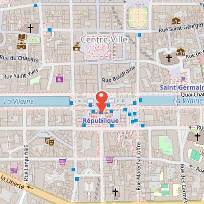
Place de la République is a rectangular square in Rennes whose form and access reflect major changes in the urban layout. Its north side retains the line of the former river quay, while the south side is bordered by the Palais du Commerce, built in the early 20th century. To the east, the square opens toward the river and the road quays beyond the Pont Jean-Jaurès, and to the west it extends the former riverside parking area toward Place de Bretagne and the Mission and Bretagne bridges.
The site is linked to the covering of the Vilaine in 1912 and 1913, an operation initiated by mayor Jean Janvier. It corresponds to the level of the second city enclosure completed in 1448, near the former Nemours or Pré-Botté quay. The square also reflects later traffic changes: motor vehicle access was gradually reduced at the end of the 20th century, then limited to residents and bicycles north of the square since 2020. Buses continue to circulate in front of the Palais du Commerce.
Nearby Objects
-
 Place de la Mairie 200 m away
 -
 Rennes Opera House 200 m away
 -
 Rennes City Hall 200 m away
 -
 Église Saint-Germain de Rennes 250 m away
 -
 Place Saint-Germain 250 m away
Situation and Access
Place de la Republique has a rectangular layout shaped by its riverfront setting. Its north side preserves the line of the old river quay, while the south side is bordered and largely occupied by the Palais du Commerce, built in the early 20th century. The square is set back from the opposite quay to the south, and its east side opens a perspective toward the river and the road quays beyond Pont Jean-Jaures. On the west side, the square extends an old parking area along the river toward Place de Bretagne and the Mission and Bretagne bridges. This arrangement allows the river to reappear just before its junction with the Canal d Ille-et-Rance.
The square has also been reshaped by changes in circulation. Motor vehicle access was progressively reduced at the end of the 20th century and reserved for buses. At the beginning of the 21st century, the north lane still carried moderate local traffic at reduced speed in an east-west direction. Since 2020, motorized traffic north of the square has been limited to residents and bicycles. A narrow traffic lane once passed through the central arcade of the Palais du Commerce, but this passage is now reserved for pedestrians. The building thus functions as a gate between the north and south parts of the city facing north.
Bus circulation remains a significant feature of the square, with numerous buses moving in both directions in front of the Palais du Commerce and requiring caution. In 2020, the municipal government announced a redevelopment project intended to reduce bus traffic.
Site Formation and Urban Transformation
Place de la Republique is located at the level of the second city enclosure, completed in 1448, where the enclosure passes through the center and the Vilaine river lies a few meters to the south. The river course at this point ran from the southwest corner to slightly below the northeast corner. The square was not the first in this sector: its central part corresponds to the former Nemours dock, also called the Pre-Botte dock. Before that, Pre-Botte dock had been created between 1840 and 1844 at the expense of Place du Pre-Botte, a market place near the Vilaine river. The Vilaine was covered between Nemours and Berlin bridges, and Place de la Republique was created in 1912 and 1913 through this work. The initiative to cover the river is credited to mayor Jean Janvier. At the time of the square's creation, Rennes had approximately eighty thousand inhabitants.
Design and Early History
Place de la Republique was designed as a parterre at the palais du Commerce, and its covering was made possible by the use of reinforced concrete. The square rests on sixty-five original arches, although part of this structure was partially destroyed in 1944. After its completion, the square received a visit from President Raymond Poincare the following year. In its early form, it featured a simple French formal garden, which was later redesigned in the 1980s. Early postcards referred to it as Les nouveaux jardins and later as Les jardins sur la Vilaine. The garden was enclosed by a strong white stone wall with a balustrade and triple-lamp streetlights, except on the south side. Inside, public benches alternated between inward-facing arrangements and peripheral alignment for pedestrians, and the garden could be closed at certain times.
Commerce, Transport, and Public Life
The history of place de la Republique is closely linked to the Palais du Commerce and the public uses that developed around it. Early postcards of the palace show only its western half, set in a barren terre-plein, while an earlier photograph records the building nearing completion beside the Pré-BottE dock. The palace was completed halfway in 1911 and fully in 1929, and its presence helped shape the square's frequentation. A fire caused by a storm left the building reduced to walls, after which state-level reaction led to restoration and the completion of the western symmetrical part.
Several institutions occupied the site over time. The Post and Telegraph administration was present from 1890 on several floors in the Hotel des Postes, and the Ecole regionale des Beaux-Arts also joined the location. The influence of the post office extended across the square, which was known as the "gardens of the Post". In 2010, the ground floor of the north facade still housed telecommunications, with a post office and telephony sales on both sides of the central arcade. The Palais du Commerce also hosted the Cercle militaire and Radio Rennes-PTT from 1926, later Radio Bretagne.
The square was also a transport node. Before World War II, Rennes tramway lines served it via Pont de Nemours and Pont de Berlin across the Vilaine. The Place de la Mairie was the neuralgic center of the tramway network. A small bus station of the north-south axis is now located approximately on the site of the Halle-aux-Toiles, which was demolished starting in 1923 in the southeast extension of the Palais du Commerce; the Halle-aux-Toiles had previously been converted into a commerce exchange.
Public life on the square was marked by the bronze statue of Mayor Edgard Le Bastard, which stood there until 1931 before being moved to Place Hoche. The statue was later melted down by the Germans during World War II. The square also gathered notable and cosmopolitan crowds during the Dreyfus trial, leading L'Illustration to describe it as a "Haut lieu de la vie rennaise". The cafe de la Paix has been present on the ground floor of the west wing near the former Pont de Nemours since the creation of the palace, and Jean Jaures was among its frequent visitors. Since the 1930s, a large commercial surface has occupied the northwest corner entrance on Rue de Rohan, and since the 1980s a large bookstore on two floors has stood opposite the Palais du Commerce.
Redevelopment and Public Use
From the beginning of the 1960s, the covered Vilaine river was extended west of the square to the Pont de la Mission, and the space above it was used as a paid parking lot until 2025. During the second half of the 20th century, the square underwent major redevelopment that included a traffic scheme and the construction of a metro station underground, despite the presence of the river below. Its former French garden was gradually replaced by combinations of green spaces and parking areas in response to user demand. A mid-1980s aerial view showed the square sharing space between cars, buses with dedicated lanes, and green areas. The central part was later renovated with Patrick Nadeau's plant libraries, along with tree planters and benches. In the 1970s, a modern pavilion at the west edge housed the syndicat d'initiative and masked the parking lot behind it. After this pavilion was destroyed at the beginning of the 1990s, it was replaced by a smaller one containing public toilets and small services. The square also reserved space between the palace wings for bus parking, while two small green areas with north-south pedestrian paths concealed paid parking lots.
Wartime Damage and Liberation
During World War II, the city escaped total destruction by Allied bombings in 1944, unlike Brest and other cities, but it still suffered localized bombings that were very deadly. At the time of the liberation, the retreating occupying forces destroyed the citys bridges. German mines destroyed the Jean-Jaures bridge and damaged part of the vault supporting the square at dawn in the liberation year, while the Nemours bridge was also cut by German mines. The blast shattered nearby windows and seriously damaged buildings on the Lamartine quay. After the city was liberated, journalists from L'Ouest-Eclair photographed the destruction, and one image shows people triumphantly carrying La Voix de la France newspaper in the square. Some photographs also show a concrete tunnel near the east wing of the Palais du Commerce, likely designed by Germans to protect telephone lines. The tunnel is about two and a half meters high and has two staircases of ten steps each on either side; in one published photograph, two German soldiers are shown crossing it.
Recent changes and public concerns
In 2016, pedestrians reported security problems linked to drug trafficking along the arcade axis, and a petition was submitted that same year to ask the authorities to stop these disturbances. More recently, the Rennes municipal council voted in 2022 to demolish the Vilaine parking west of the square. This project is intended to uncover the canal beneath Place de la Republique and create a new promenade area. The parking was definitively closed in early 2023, reconstruction began at the end of the year, and the reconversion work is scheduled for completion by summer 2028.