Argentoratum, also written Argentorate, is the ancient name of the present-day city of Strasbourg. The Latin name, of Celtic origin, designated the Roman camp founded by General Nero Claudius Drusus in the province of Upper Germania. In the 1st century, the site became the capital of Germania Prima, although it did not have legal city status like some other Roman settlements. Archaeological remains of its fortifications are preserved in the cellars of Strasbourg’s city centre.
Excavations have also revealed traces of earlier occupation, including objects from the Neolithic, Bronze Age, and Iron Age. The site developed into a Celtic town with a sanctuary and market, before becoming a Roman military centre. Archaeological findings include baths, residences, and a military hospital. The camp grew over time, hosted successive military units, and later received a limestone wall in the 3rd century. Argentorate also functioned as a commercial crossroads, especially for river traffic, with imports and exports passing through the port near Saint-Thomas church.
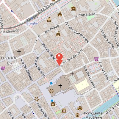
Nearby Objects
-
 Strasbourg astronomical clock 90 m away
 -
 Cathedral of Our Lady of Strasbourg 90 m away
 -
 Place de la Cathédrale 150 m away
 -
 Musée archéologique de Strasbourg 200 m away
 -
 Temple Neuf 200 m away
Argentoratum and Its Roman Past
Argentoratum, also written Argentorate, is the ancient name of the present-day city of Strasbourg. The name is a Latin denomination of Celtic origin, derived from arganto- and rati-. It referred to the Roman camp founded by the general Nero Claudius Drusus in the province of Upper Germania. In the 1st century, Argentoratum served as the capital of Germania Prima. Although it was an important Roman settlement, it did not constitute a city in the legal sense, unlike Mogontiacum, Augusta Treverorum, or Augusta Raurica. Archaeological remains of its fortifications are still preserved in the cellars of Strasbourg city center.
From Celtic Settlement to Roman Camp
Archaeological excavations at Argentoratum have uncovered numerous objects from the Neolithic, Bronze Age, and Iron Age, indicating a long sequence of occupation before the Roman period. Histoire reports that the durable installation of protoceltic peoples dates to around 1300 BC. By the end of the Iron Age, the site had become a Celtic town named Argentorate, with a sanctuary and a market. At that time, houses on stilts were replaced by dwellings built on firm ground, made possible by major drainage work.
The Romans arrived in Alsace in 58 BC and settled on the Strasbourg site. Histoire mentions a belief that General Drusus built a military camp there in 12 BC, over a small Gallic city, and that the camp between two arms of the Ill river was named after the Roman camp. However, archaeological finds and source analysis indicate that the Roman camp dates only from the first century AD. The camp initially housed a military post monitoring Roman roads in Upper Germania province.
The site then grew with the installation of the 8th legion between 15 and 43 AD. There was no legion present between 43 AD and the 90s AD, but from the 90s AD the 12th Augustan legion remained there for a long period in a camp covering a large area. Excavations have revealed substantial remains of baths, residences, and a military hospital. In the 3rd century, soldiers built a limestone wall that replaced the original earth and wood rampart.
Military and Commercial Role of Argentoratum
Histoire describes Argentorate as a military colony in which legionnaires installed their families, while also identifying it as a commercial crossroads. River traffic at Strasbourg port near Saint-Thomas church connected the site to wider exchange networks. Imports included amphorae and manufactured goods, and exports included Alsace wines and pottery from the workshops of Heiligenberg. Despite this commercial activity, the city remained primarily military and dependent on military activity. During the 2nd and 3rd centuries of Roman expansion, Argentorate became an important supply base and a fallback point for Roman troops in Germania. After the legions left Germania in 260 AD, Strasbourg became a border town guarding the Rhine limes against foreign barbarians. It then transformed into a fortress hosting approximately 6,000 legionnaires. Histoire also suggests that several hundred inhabitants may have continued to live throughout the Early Middle Ages inside the deserted Roman enclosure.
Roman Camp Enclosure at Argentoratum
The site of the Roman camp at Argentoratum covers 19 ha on the Grande ile and retains its original layout in the city topography, enclosed by the arms of the Ill and Bruche waterways. Its perimeter and axes are still partly visible in the present rues du Dome and rue des Hallebardes. The camp was established by Legion VIII on an alluvial terrace above swampy lowlands, where the ground was leveled and filled to a height of ten centimeters.
Over three centuries, the defenders built three successive enclosures. The earliest was an earth enclosure with a wood framework, preceded by a curved ditch 5 to wide and to deep. In the mid 1st century AD, a second limestone wall was built in front of the earth and wood wall. This phase included rectangular towers projecting inside the camp. The first ditch was filled and a second ditch was dug farther out. The wall rested on volcanic stone foundations from Kaiserstuhl, set in a trench 1 to wide and deep, and was made of small limestone rubble interrupted by horizontal chains of three courses of bricks or tiles.
At the end of the 2nd or start of the 3rd century AD, a third and last wall was built of sandstone. It was constructed in stages and abutted directly against the limestone wall. This enclosure featured many semi-circular towers spaced 20 to apart, as well as larger round corner towers. Archaeology has identified seventeen semi-circular towers of varying diameters on different fronts. The enclosure also included reused funerary steles and other sculpted or inscribed fragments.
Remains of the Roman enclosure are integrated into buildings near place du Temple-Neuf and in cellars at 47-49 rue des Grandes-Arcades, where they were unearthed in 1906 and classified Monument Historique on 27 December 1920. Additional remnants have been discovered and displayed under Saint-Etienne church and Gymnase Jean-Sturm.
The Roman Camp at Argentoratum
Roman presence at Argentoratum is attested until the invasion of the Huns in 451 AD. The final phase of the Roman camp is well known from archaeological excavations. The camp enclosure measured 520 meters long and 490 meters wide, enclosing an area of 19 hectares. This size was standard for Roman camps, which typically covered between 18 and 20 hectares. The Strasbourg camp was smaller than other Rhine camps measuring 25 hectares.
Water Boundaries of the Camp
The camp was bordered by existing watercourses and ditches that are still reflected in Strasbourg's topography. Its southern enclosure ran along the Ill river between Pont de la Place du Corbeau and Eglise Saint-Etienne. At that time, the Ill was about 100 meters wider and reached rue des Veaux. On the eastern side, the moats of the wall formed the downstream part of the Faux-Rempart ditch. This ditch continued north through the now disappeared Fossé des Tanneurs near Place Broglie, then west by the disappeared Ulmergraben ditch along rues des Grandes-Arcades and du Vieil-Hopital.
The Gates of Argentoratum
The Argentoratum camp was accessed through four gates: the porta praetoria, porta decumana, porta principalis dextra, and porta principalis sinistra. The principal monumental gate was the porta praetoria, which served as the official gate to the praetorium headquarters. It was located to the west, at the corner of rue des Hallebardes and rue du Fosse-des-Tailleurs. The via praetoria, the west-east axis, corresponds to the present-day rues des Hallebardes and des Juifs.
The porta decumana stood to the east, at the middle of quai Lezay-Marnesia. Excavations in 1971 and 1972 revealed the full plan of this eastern gate, showing a rectangular main body over the courtine and two rectangular bastion towers. Its passage originally measured 9.7 meters in width, but this was reduced to 6.5 meters in late antiquity.
The porta principalis dextra was placed to the north at the entrance of rue du Dome, while the porta principalis sinistra was to the south at rue du Bain-aux-Roses. These two gates are poorly documented. Together, the north-south axis of the camp, the via principalis, corresponds to the present-day rue du Dome and rue du Bain-aux-Roses, interrupted by the Grand Seminaire and the Lycee Fustel-de-Coulanges.
Archaeological Remains and Roman Context
Vestiges archéologiques recorded several Roman-era remains in the area, including many Roman objects found along the current Roman road in the Koenigshoffen neighborhood west of downtown. The site also yielded fragments of a large mithraeum that had been broken by early Christians. In another Roman context, Largo di Torre Argentina was identified as a large rectangular square on corso Vittorio Emanuele in the Campo Marzio district of Rome, occupied almost entirely by an archaeological complex with four Republican era Roman temples. The name of Largo di Torre Argentina refers to Torre Argentina, a tower now included in a building. Johann Burchard, who was master of ceremonies for five popes starting in 1483, named the tower and was from Strasbourg, known in Latin as Argentoratum, signing his writings as Argentinus.