Porte de Valenciennes is a public urban square in the commune of Lille, in the Nord department of France. It occupies the area of a former city gate of Lille’s walls and was created in 1860 facing the Porte de Valenciennes, which formed part of the new fortified enclosure built that year. The fortifications and the gate were dismantled in the 1930s.
The area around the square includes land that was formerly part of a military zone before the wall was destroyed. After demolition, the freed land was used for social housing and road axes around 1960. Since 2006, the sector has been undergoing restructuring, and the ZAC de la Porte de Valenciennes was created in that year.
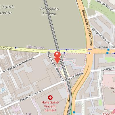
The site lies northeast of the Lille-Moulins district, at the eastern end of the streets Cambrai, Valenciennes, and Trévise. It is served by the Porte de Valenciennes metro station on line 2.
Nearby Objects
-
 Maison Folie Moulins 700 m away
 -
 Porte de Paris 950 m away
 -
 Église Saint-Sauveur de Lille 1000 m away
 -
 Belfry of Lille 1000 m away
 -
 Synagogue de Lille 1100 m away
History and Urban Transformation
Porte de Valenciennes was part of the new fortified enclosure built in 1860, and it was created facing the former city gate of the Lille city walls. The fortifications and the Porte de Valenciennes were dismantled in the 1930s. Around 1960, the land freed by this dismantling was used for social housing and road axes. In 2006, the ZAC de la Porte de Valenciennes was created, and the sector has been undergoing restructuring since then.
Location and Access
Porte de Valenciennes is located northeast of the Lille-Moulins district, in the Valenciennes gate area. It lies at the eastern end of the streets Cambrai, Valenciennes, and Trivise, and refers to a space larger than the Guy de Dampierre square. The area includes the former military zone that was located before the city wall destroyed during the 1930s. Its northern limit is formed by the exit roads of the former Saint-Sauveur station, while the eastern ring road and Belfort boulevard define other boundaries. To the south, it extends to the level of the metro station. The area is served by Porte de Valenciennes metro station on line 2.
Origin of the Name
Porte de Valenciennes was opened in 1863 within the enclosure built during the 1860s at the end of Rue de Valenciennes. It was named because it led to Route de Valenciennes, which passed through the Mont-de-Terre district in Fives. Inside the rampart at the entrance to this structure is Place de la Porte de Valenciennes, which was renamed Place Guy-de-Dampierre in 1886. The new name referred to the Count of Flanders from 1253 to 1305, whose name is sometimes spelled Gui de Dampierre.
From Rural Edge to Urban Gate
The area around Porte de Valenciennes began as a rural zone near the faubourg des Malades or faubourg de Paris, outside Lille's enceinte, along the route de Valenciennes near the parish of Wazemmes. After the closure of porte Saint-Sauveur in 1575, following a powder depot explosion, a section of the route de Valenciennes was diverted. The old route later became known as the vieux chemin de Saint-Sauveur in 1853, before disappearing during the expansion of gare Saint-Sauveur. Porte Saint-Sauveur itself was destroyed in 1673.
The plain around the route de Valenciennes contained many mills, and the faubourg de Paris later became the autonomous commune of Moulins-Lille in 1833, separated from Wazemmes. Industrial development then increased on the southern side of the route de Valenciennes. Le Gavrian, a mechanical construction company, was created there in 1837 on the future place Guy-de-Dampierre site, which is now the usine Crepelle-Atlas-Copco. Other factories were established on the same side of rue de Valenciennes during the same period.
Urban and military planning also shaped the sector. Place de Valenciennes was opened in 1863 at the exit of the route de Valenciennes and the gate entrance, later renamed place Guy-de-Dampierre. Gare de marchandises Saint-Sauveur opened in 1865 inside the new enceinte, north of the former Moulins commune and rue de Cambrai. A military street was opened from the Noble Tour to porte de Dunkerque, and the freight railway belt line linked gare Saint-Sauveur to the docks of port-Vauban. This street was named boulevard du Marichal Vaillant in 1863, then divided in 1872; the section from the Noble Tour to porte de Valenciennes kept that name, while the section from porte de Valenciennes to porte de Douai became boulevard de Belfort.
The fortifications around porte de Valenciennes included an inundated ditch fed by the Becquerel or ruisseau de Fives, extending from the north to the gate and, on some maps, as far as porte de Douai. Beyond the bastioned defenses, the military servitude zone was particularly large and functioned as a maneuver field extending toward Ronchin. In the late 19th century, the north side of rue de Valenciennes remained unbuilt until the end of the century, while eclectic townhouses were built around 1900 in the triangle formed by rues de Valenciennes, de Cambrai, and de Coulmiers. Tramway lines T and V also crossed porte de Valenciennes, connecting it to wider parts of the city and its southern quarters.
Dismantling and Urban Reuse
The dismantling of the enclosure was decided by a 1919 law, following two decades of debates. This law kept a construction ban in the declassified military zone for expropriations, and it also reserved 20 percent of the released surface for low-cost housing. The demolition of the fortifications then took place over about twenty years. The Porte de Valenciennes itself was destroyed in 1935, while nearby fortifications were demolished during the 1930s. After World War II, the abandonment of an airfield increased the area available for workers' gardens before later urbanization.
Transport Changes and Urban Rebuilding
The history of Porte de Valenciennes is closely tied to successive changes in transport infrastructure and urban reconstruction. During the Second World War, the Saint-Sauveur station tracks crossing Boulevard du Marichal Vaillant were removed and replaced by a pedestrian footbridge at the edge of an empty lot now called Belvedere. This footbridge was itself removed in the 1950s. In 1955, a bridge was built over the Saint-Sauveur station exit tracks and the first section of the peripheral boulevard, extending along Boulevard du President Hoover and the four-lane Avenue Paul Painleve. At that time, Avenue Paul Painleve continued the future A1 highway between Paris and Lille, whose first section had opened in 1954 between Lille and Carvin.
The highway works also affected local connections toward Fives. The crossing of the route to Fives remained at grade with traffic lights, serving Rue du Faubourg de Valenciennes, now part of Rue de Cambrai, and Avenue Denis Cordonnier. Avenue Denis Cordonnier led to the Pont de Tournai built on the axis of Rue Chanzy in Fives. Before 1954, the Mont-de-Terre connection used Rue de Bavay along the railway north side, opposite Avenue Denis Cordonnier, and crossed a bridge on the axis of Rue Malesherbes in Fives. This old bridge was removed during the creation of the new Pont de Tournai.
The area was also altered by major housing construction. Between 1958 and 1959, HLM housing bars in prefab elements were built between Place Guy-de-Dampierre, Boulevard de Belfort, and the boulevard peripherique, with priority given to rehousing inhabitants of the Saint-Sauveur quarter under reconstruction. New university residences were also built across the boulevard peripherique, between the railway and Avenue Denis Cordonnier, opposite the demolished 1930s residence. These road and housing projects led to the disappearance of workers gardens at the end of the 1950s.
Later changes continued this transformation. Tramway line V was replaced by a bus service in 1960 after tramway line T had been removed in 1947. In 1975, the level crossing at Porte de Valenciennes-Mont-de-Terre on Avenue Denis-Cordonnier was replaced by an overpass and pedestrian bridge. The railway belt line was removed in 1983, and a metro line 2 viaduct was then constructed on its former location, opening in 1989 with service to Porte de Valenciennes station. In 1988, the boulevard peripherique was diverted eastwards and the level crossing on Boulevard Paul Painleve was restored, with the removal of the overpass and pedestrian bridge. These changes helped transform Boulevard Paul Painleve from a highway axis into an urban boulevard and improved the sector environment.
Urban Redevelopment at Porte de Valenciennes
The ZAC de la porte de Valenciennes was created by deliberation of the Community Council as an extension of 16 hectares of the Euralille project. It covers a 16-hectare territory at the end of the Moulins-Lille district, between Euralille II to the north and the former Saint-Sauveur station site to the west. It also borders the Porte de Douai sector to the south of the metro station Porte de Valenciennes and the highway to the east. The project was intended to develop an urban area on an isolated, peripheral, and fragmented territory.
The redevelopment involved major changes to the existing built environment. In 2009, the 1958-1959 Belfort HLM buildings were demolished, except for the Clemenceau tower, which was rehabilitated on the new Place du Lin near the metro station. Boulevard de Belfort was diverted to connect to Boulevard Paul Painleve. The development program covers an area made up of 67 percent housing, 25 percent offices, and 5 percent commerce, with 30 percent of the housing reserved as social housing units. Buildings along Avenue Paul Painleve were planned to have a height similar to those on Avenue du President Hoover, while other buildings were planned in the form of garden blocks.
The area includes several specific facilities and redeveloped sites. The Stephane Hessel youth hostel opened in 2015 and includes a nursery and social economy businesses. University residences built in 1960 on Avenue Denis Cordonnier were redeveloped into social housing and temporary accommodation. The Rectorate building on Rue Saint-Jacques was replaced by a new building on Rue de Bavay to the north of the ZAC. The area also hosts the Regional Institute of the City. Several hundred housing units were delivered, with relatively few commercial spaces, and the planned share of commercial activity remained low despite the surrounding neighborhoods lacking such services.
A 2-hectare Belvedere wasteland is included in the sector, in the triangle between the Saint-Sauveur station area, Boulevard Paul Painleve, and Rue de Cambrai. The site lies on fill from former bastioned fortifications, and parts of it were used as workers' gardens or as a vacant lot used for children's play space in the 1950s. Its lack of buildings made possible the construction of a highway bridge in 1975, later removed in 1988, and a metro viaduct. Although the program included a green space development on the Belvedere wasteland, the park project was later abandoned after a report from the Lille European Metropolis, and the site was transferred to the Saint-Sauveur ZAC for a planned Olympic swimming pool and other buildings.