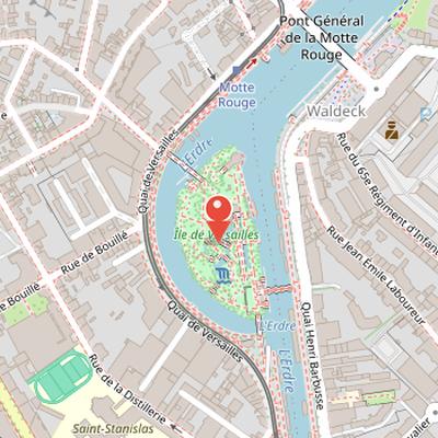
Île de Versailles is an artificial river island and urban park in Nantes, located on the lowest course of the Erdre near quai Ceineray, in the Hauts-Pavés - Saint-Félix district. It is geographically closer to the right bank near quai de Versailles than to the left bank near quai Henri-Barbusse. The island is accessible by a stone bridge at the south end, built around 1845, and by two metal footbridges installed around 1988 at the south-east and north-west.
The site has a long history of changing names and uses. It was successively called marais de Barbin, île Le Gall, and île aux Singes, and took the name Versailles in 1878, referring to the property called petit Versailles on the 1756 plan Cacault. The island also had a varied industrial and craft past. Before 1831, it appeared on a 1761 map as a swamp. From 1831, it received earth excavated from the Nantes to Brest canal and hosted laundries, carpentry, tanneries, forges, boat construction, fisheries, and taverns for more than a century. A garden park development followed after a period of decline from the 1950s. Another area, Paysage japonais, was developed after the city completed the acquisition of the last plots in 1986.
Nearby Objects
-
 Monument aux 50 Otages 600 m away
 -
 Saint-Félix Church 600 m away
 -
 Église Saint-Similien 700 m away
 -
 Saint-Clément 750 m away
 -
 Place Maréchal-Foch 800 m away
Names and Toponymy
The site now known as Ile de Versailles has undergone several name changes. It was successively called marais de Barbin, after the village on the right bank, then ile Le Gall, and later ile aux Singes. Along its east side, it took the name quai de Versailles. The name Versailles was assigned in 1878. It refers to a large property called petit Versailles, which appears on the 1756 plan Cacault. This property extended from route de Rennes to rues Chateaubriand and Adolphe-Moitie.
Location and Access
Ile de Versailles is an island in the lowest course of the Erdre River near quai Ceineray, in the Hauts-Paves - Saint-Felix district. It is geographically closer to the right bank near quai de Versailles than to the left bank near quai Henri-Barbusse. The island can be reached by a stone bridge at the south end, built around 1845, and by two metal footbridges installed around 1988 at the south-east and north-west.
From Swamp to Artisan River Site
In 1761, the site was shown on a map as a swamp. From 1831, it began to receive earth excavated from the Nantes to Brest canal. Over more than a century, it hosted a range of river-related and craft activities, including laundries, carpentry, tanneries, forges, boat construction, fisheries, and taverns. In 1844, Mathurin Peccot presented plans to transform the site into a large laundry with a central basin. The plan called for a basin about one hundred meters long, fed by five canals. From the 1950s, the site was somewhat abandoned before garden park development, although it continued to be occupied by diverse artisan river-related activities and naval construction and repair after that period. The pedestrian bridge linking it to Quai de Versailles was renovated in 2025.
The Japanese Landscape Project
The Paysage japonais development was launched after Nantes completed the acquisition of the last plots in 1986. It took place during the mayoralty of Michel Chauty, who served from 1983 to 1989. The architectural project was chosen through a competition among architects, and the selected team included Jacques Dulieu, Claudine Breton, Michel Cormier, and Michel Dudon. Landscape architect Louis Soulard complemented the project team. The design was based on the theme of Japan, giving the site a clearly defined cultural orientation within the island's development.