Parc des Buttes-Chaumont is a public garden in the northeast of Paris, France, in the 19th arrondissement. Inaugurated on April 1, 1867, during the last years of Napoleon III's reign, it was designed by engineer Adolphe Alphand with landscapers Jean-Pierre Barillet-Deschamps and Édouard André. Covering nearly 25 hectares, it is one of the largest green spaces in Paris.
The park is conceived as an English-style garden that imitates a mountain landscape. Its composition includes rocks, cliffs, torrents, waterfalls, a grotto, alpine pastures, and belvederes. The site’s name is linked to the area’s former infertile and uncultivated condition: the subsoil was marly and highly gypsiferous, the land was sterile and unsuitable for cultivation, and no vegetation had established there. The hills were also known as Mont Chauve or Chauve-Mont, names that contracted to Chaumont. The park has a concave plan, with the northeast side remaining rectilinear along rue de Crimée.
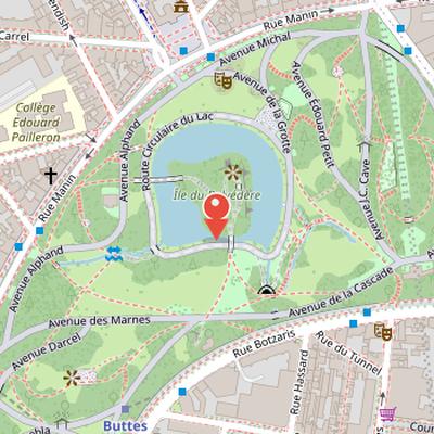
Nearby Objects
-
 Stade Bergeyre 550 m away
 -
 Cours Florent 800 m away
 -
 French Communist Party headquarters 850 m away
 -
 Place de la Bataille-de-Stalingrad 1000 m away
 -
 Hôpital Saint-Louis 1200 m away
Design and Setting of Parc des Buttes-Chaumont
Parc des Buttes-Chaumont is a public garden in the northeast of Paris, France, in the 19th arrondissement. Covering nearly 25 hectares, it is among the largest green spaces in the city. The park was inaugurated on April 1, 1867, during the last years of Napoleon III's reign. It was designed by engineer Adolphe Alphand together with the landscapers Jean-Pierre Barillet-Deschamps and Edouard Andre. The park is laid out as an English-style garden and is intended to imitate a mountain landscape. Its design includes rocks, cliffs, torrents, waterfalls, a grotto, alpine pastures, and belvederes.
Origin of the Name Buttes-Chaumont
The name Buttes-Chaumont is linked to the poor natural conditions of the site. The subsoil was marly and highly gypsiferous, which made the area sterile and unsuitable for cultivation, and no vegetation had established there. The hills were also known as Mont Chauve or Chauve-Mont, names derived from Latin, which later contracted to Chaumont, as explained by Baron Haussmann in his Memoires. According to the toponymic record, this name existed in the 17th century but gradually fell into disuse by the 19th century. In the 18th century, female religious communities settled in the Buttes neighborhood and were called the Filles de Saint-Chaumont because they occupied the former mansion of Melchior Mitte de Chevrieres, Marquis de Saint-Chamond, also known as Marquis de Saint-Chaumont. It is possible that the name of these communities also contributed to the naming of the hills.
Location and layout
Parc des Buttes-Chaumont is located in the northeast of Paris, in the south of quartier du Combat. It is bordered by rue Manin at the west and northwest, rue de Crimmee at the northeast, rue Botzaris at the south, and avenue Simon Bolivar at the southwest. The park is also associated with the western margin of the Belleville and Romainville hills, within the geological context of the Bassin parisien.
The park is the fifth largest green space in Paris, after the bois de Vincennes, bois de Boulogne, parc de la Villette, and jardin des Tuileries. Its form is concave, with only the northeast side rectilinear along rue de Crimmee. The presence of its quarry heritage is reflected in an elevation difference of more than an unspecified amount. Rues Manin and Botzaris surround the park at the northwest and southeast respectively, while avenue Simon Bolivar extends rue Manin and meets rue Botzaris at the south, forming a point.
Parc des Buttes-Chaumont has six main entrances and nine secondary entrances. Inside the park there are fourteen paths, along with areas of lawns, wooded areas, rockeries, and circulation spaces. The closest metro stations are Buttes-Chaumont and Botzaris on line 7 bis to the south, with Laumiere on line 5 and Bolivar on line 7 bis nearest to the north and northwest.
Geological Setting of Buttes-Chaumont
The Buttes-Chaumont site belongs to the hills that close the northeast edge of the amphitheater-shaped alluvial plain where Paris extends. This hill range, peaking at Belleville, dominates the lower plain where the Seine has shifted its meander, and its formation is linked to the incision of the Seine affecting the Meudon anticline. Quaternary erosion left only a few hills standing, exposing much of the tertiary formations of the Bassin parisien, including limestones, gypsum, clays, sands, and millstone.
Buttes-Chaumont, like Montmartre, is mainly composed of gypsum rocks covered by marl layers. These marl layers include the blue marl of Argenteuil and the white marl of Pantin. The subsoil contains three gypsum layers of varying thickness separated by marl. These gypsum and marl formations belong to the upper Eocene stage known as the Ludien. The site dates to about forty-five million years ago, within a large lagoonal-lacustrine complex shaped by transgression and regression cycles.
The third gypsum mass is the oldest, deepest, and thinnest, measuring about three meters. It rests on a pholadomye marl layer and represents a large evaporitic lagoon deposit, marking the end of the marine sedimentation phase. Above it lies a lucine marl layer separating it from the second gypsum mass, which is about five meters thick. A marl layer called d'entre-deux-masses forms the boundary between the second and first gypsum masses. The first gypsum mass is the most recent and thickest, at about fifteen meters, and the first and second masses are deposits from an evaporitic lake formed after the closure of the lagoon.
From Quarry and Gibbet to Urban Park
Before landscaping, the site of Buttes-Chaumont was among the most desolate places near Paris and had a sinister reputation. From the Middle Ages until the 18th century, royal justice was rendered at the foot of the buttes, and the Montfaucon gibbet stood there as a place of execution under Ancien Regime justice. Executions ended in the 18th century, and the gibbet was dismantled between 1760 and the French Revolution. The site then became a large open-air dump known as the voirie de Montfaucon, where waste and excrement collected by Paris cleaners were deposited. A suburb developed around this dump, bringing chemical and fertilizer manufacturers, knackers, tanners, and maggot producers for fishermen. In the first half of the 19th century, the area was the main Paris knackery center, until the Villette slaughterhouses opened in 1867. Around 100,000 cattle and 200,000 sheep were slaughtered annually, and their carcasses were dumped in the pit, creating mephitic odors that spread over Paris.
The subsoil also played an important role in the site history. After the French Revolution, the Butte Saint-Chaumont was exploited for gypsum and millstone quarrying in the former Belleville commune, and quarrying continued until 1860, the year Belleville was annexed to Paris. The quarries were arid and without vegetation in 1852, and the Carrieres d'Amerique quarries were said to be filled with needy people at night. Researchers such as Georges Cuvier discovered mammal fossils there, including Palaeotherium, a horse-related animal from the Eocene epoch about 50 million years ago. Because gypsum extraction had ended and the land was unsuitable for building due to the risk of underground collapse from gypsum dissolution, the quarry site was designated for a park. It was then transformed into an urban park under Napoleon III's Paris works, with Baron Haussmann appointed prefect of the Seine to plan those works.
Planning and Design of the Park
The parc des Buttes-Chaumont was created within a broader Parisian project to establish a network of green spaces. Under Napoleon III, public gardens were intended to provide leisure areas for all social classes and to help transform Paris into a green city for sanitation and beautification. Inspired in part by the hygienist parks of London seen during his English exile, this approach organized new green spaces within a hierarchical system of promenades, arranged by size. In this framework, the parc des Buttes-Chaumont belonged to the category of urban parks, alongside parc Monceau and parc Montsouris, between the larger bois de Boulogne and bois de Vincennes and the smaller squares in Paris districts.
Baron Haussmann commissioned Adolphe Alphand to design and build the park. Alphand, who served as chief of the promenades and plantations service in Paris, was a polytechnic and bridge engineer with several landscaping projects in the city. For this project, he assembled a team of engineers and landscape architects. Jean Darcel, a bridge engineer, handled technical details. Jean-Pierre Barillet-Deschamps, the chief gardener, drafted the project and advised on paths, valleys, and plants, while Edouard Andre assisted him as a landscape architect in charge of works. Gabriel Davioud designed the buildings, architectural elements, and park furniture, and the hydraulician Eugene Belgrand planned the water supply and circulation systems.
Planning and Construction of Buttes-Chaumont
In 1862, the Paris municipality contacted the Societe civile des carrieres du centre to acquire the park lands. An imperial decree then declared the Buttes-Chaumont lands to be for public use, which made expropriations possible. The initial studies and general project by engineer Darcel were presented to the municipal council, and the park project became part of the wider enthusiasm for Adolphe Alphand's public green space program in Paris. The project was also discussed by architect Cesar Daly in the Revue generale de l'architecture et des travaux publics, while the Revue de Paris later described the site as having been transformed from a barren rock into an oasis by Alphand's team, and attributed the origin of the project to the titanic imagination of Baron Haussmann.
Construction lasted five years and the relief shaping was the first and longest phase, beginning in 1864. Alphand noted that during the first year only rough earthworks were carried out, and the entrepreneur responsible for leveling work was reprimanded because progress was slow. Earthworks continued through 1865 and 1866. Darcel later created a new version of the park plan, without specifying the retained plant species. Plantations began on the Puebla mound at the end of 1865, and most of the planting was completed in 1866. Landscaping and horticultural work then continued alongside the development of circulation roads between 1866 and 1867, when the roads were also macadamized.
The Park During the Paris Commune
During the Paris Commune of 1871, the Parc des Buttes-Chaumont contained a battery established by the Communards at the park summit. This position was one of the last Communard strongholds, and the Communards under Gabriel Ranvier bombarded the Thiers troops until the end. During the Bloody Week, the park was turned into a slaughterhouse by the Versaillais. Under Adolphe Thiers, Patrice de Mac Mahon, and officers, more than eight hundred unarmed workers, including women and children, were massacred there. At least four hundred bodies were thrown into the park lake, where they later surfaced swollen. The park was also transformed into a large body incinerator, and many bodies were buried in abandoned wells in adjacent streets and in the neighboring Carrieres d'Amerique.
Landscape Design and Engineering
Un jardin d'ingenieurs treated the topography of the Buttes-Chaumont gypsum quarries as both a design problem and a source of scenery, with the stated aim of imitating a mountain landscape. The project presentation distinguished two zones with different treatments. In the western sector, called the mamelons de glaise, the design sought to imitate a pre-Alpine landscape. The original relief was remodelled by preserving three buttes and flattening other mounds. These buttes were then raised to preserve the complete Paris panorama, with butte Puebla becoming the highest point of the park and butte Fessart arranged as a belvedere facing Montmartre.
The central and eastern sectors were designed with rough terrain as an alpine decor. The open-pit quarry face was integrated into this setting, while the central promontory was identified as a major landscape element, described as an enorme rocher. This promontory was detached from the other buttes to form the island of Belvedere, which was surrounded by a lake. The island was a gypsum mound covered with marl, and the quarry face was softened and redesigned to stabilize the cliffs. Excavated materials from the lake were reused to increase the height of the promontory, which was doubled to about thirty meters. The resulting cliffs were made to resemble the Alps and the chalk cliffs of Normandy.
The design also included a rocky peak and arch referencing the plaster quarries, modeled after the needle and arch at Etretat. This Norman coastal reference may have been linked to Darcel's family origins, since he is described as an engineer who owned a castle in Henouville. A staircase of 173 steps was built inside the rock to allow descent to the lake, although it is now closed to the public. On the south shore of the lake there is also a cave, a former entrance to an underground quarry, with reinforced concrete fake stalactites.
The creation of the park required major earthworks. More than one thousand workers carried out terracing operations over two years. Over one hundred horses and two steam machines were used for material transport, and a mobile railway was installed for this purpose. Wagons brought soil from the La Villette slaughterhouse site to cover poor marl soil, and the work involved moving one million cubic meters of terrain and rocks.
The finished park includes a roughly circular lake of a specified size with a diameter of approximately a specified measure and a steep island approximately a specified height in the center. The lake is fed by three streams descending the park slopes on the west, east, and south. The southern stream, fed by the Villette basin, enters the cave as an artificial waterfall of a certain height. The eastern part of the park is crossed by the Petite Ceinture railway line, with its southern part in a tunnel and its northern part in a trench.
Bridges in the Park
Parc des Buttes-Chaumont includes four bridges, which reflect the park's varied engineering and landscape design. One of the best known is the suspended footbridge designed by Gustave Eiffel and built in 1867. Its central span crosses the lake and links the shore to the Ile du Belvedere. The island is also connected to the rest of the hills by a stone masonry bridge with a single arch, spanning 15 meters and measuring 7 meters in height. This bridge was nicknamed the bridge of the Suicided because many suicides were mentioned there from the 1900s onward.
The park also has a concrete bridge crossing the Petite Ceinture line near Rue de Crimee. A metal footbridge previously stood near the same area, but it has since been dismantled. Another bridge is located at Porte Secretan, where it links the Puebla and Fessart hills. This structure is nicknamed the Eiffel bridge after its designer and is built as a metal lattice with brick vaults. Its abutments are made of rubble stone masonry using millstone stones.
The Temple of the Sibyl
The central architectural element of Un jardin d'ingnieurs is the Temple of the Sibyl, set atop the gypsum mound of the Ile du Belvedere. Designed by Gabriel Davioud, it is the only neoclassical construction in the park attributed to him. The temple sits on an artificial rock base made of Jura stone with holes and contains a podium inside this base. It is a rotunda with eight composite order columns that support a stone dome crowned with a neo-Gothic pine cone finial. The structure is decorated with friezes featuring acanthus leaves and lion heads. In its design, it uses architectural codes from ancient Greek and Roman architecture and resembles the Temple of Vesta at Tivoli and the Monument of Lysicrates in Athens. Davioud also built a Temple of the Sibyl in the Bois de Vincennes on the Ile de Reuilly for Un jardin d'ingnieurs.
Entrances and Pavilion Design
Un jardin d'ingénieurs designed the guard pavilions for the six main entrances of the park. These pavilions adopted a rationalist style, which contrasts with the firm's works at Bois de Boulogne, where it had used the parc de chateau style. At Buttes-Chaumont, the guard pavilions belong to an industrial architecture marked by brick motifs and colored ceramics.
The same firm also designed three chalet-restaurants at different points in the park. The Pavillon du Chemin de Fer is located on the hill pierced by the Petite Ceinture railway tunnel and is currently operated under the name Rosa Bonheur by a film company. The Pavillon Puebla stands on the side of the Puebla hill, while the Pavillon du Lac is placed on top of a hill overlooking the Belvedere lake.
These buildings were designed in a style intended to remain in harmony with the alpine landscapes recreated by Alphand's team. The style borrows mainly from the architectural imagination of Swiss chalets. Brick polychrome colonnades and arcades supporting a loggia also indicate the influence of northern Italian villas, an influence that is especially visible in the Pavillon du Lac.
Biodiversity in the Park
The park contains a varied biodiversity of trees and birds. Its plantations include many tree species such as sophora, oriental plane tree planted in 1862, American false indigo, and Byzantine hazel. It also includes two ginkgo bilobas, Siberian elm, and cedar of Lebanon planted in 1880. The park is populated by many bird species, including crow, house sparrow, wood pigeon, city pigeon, common starling, magpie, blackbird, coal tit, blue tit, European greenfinch, chaffinch, robin, Eurasian nuthatch, wren, and dunnock. Spring species observed there include blackcap, common swift, and pied flycatcher, while occasional visitors include long-tailed tit, garden creeper, green woodpecker, great spotted woodpecker, kinglets, stock dove, song thrush, Eurasian jay, window swallow, chiffchaff, common kestrel, European sparrowhawk, and tawny owl. In the lake, aquatic species are seen mainly in winter, including moorhen, mallard, Rouen duck, Barbary duck, northern pintail, grey heron, herring gull, and black-headed gull, as well as red-breasted goose, Canada goose, and barred-headed goose. The grey wagtail is also observed, and the common kingfisher is sometimes seen at the lake.
From the Second Empire to the Present Park
Parc des Buttes-Chaumont underwent several changes from the Second Empire to its present form. The park was inaugurated on an unspecified date and was later classified as a site by official decree on an unspecified date. In 1906, a bronze statue of Jean-Paul Marat was transferred from the Jardin du musee Carnavalet to the park. It remained there until World War II, when it was melted down. A new Jean-Paul Marat statue was recreated in 2012 using an original plaster found, and it was placed in front of the Musee de la Revolution francaise in Vizille.
The park also saw other changes in use and construction. The Stade Bergeyre was built in the southwest of the park in 1918, then demolished in 1926 to make way for a housing subdivision called Butte Bergeyre. In recent years, park management has been altered following initiatives by Parisian ecologist Verts elected officials. These changes included ending regular mowing of certain lawns in favor of cutting to promote diverse flora, as well as acquiring a small mountain tractor for maintenance of the park's steep slopes.