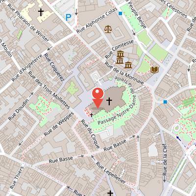
Place Gilleson is a square in Lille, in the Nord department of France. It is located in the Vieux-Lille district, near Notre-Dame-de-la-Treille cathedral. The square occupies a site long associated with Lille’s earliest urban development, including the former motte castrale mentioned in a 1066 charter by Count Baudouin V of Flanders. The area stood at the center of the city’s original core, near the old Lille port on the Basse Deûle and at the crossroads of roads to Ypres, Ghent, and Paris.
The site’s medieval history is poorly documented, but it appears on late 18th- and early 19th-century maps as a sparsely built area. In 1801, a leisure complex called the “cirque” was established there, with an English garden, theater, café, library, and baths. After a brief period of popularity, the complex declined, and the hill later became wasteland before being leveled in 1848. The nearby Notre-Dame-de-la-Treille cathedral was built from 1857 to 1999 on land purchased in 1853 by the Notre-Dame de la Treille and Saint-Pierre commission.
Nearby Objects
-
 Lille Cathedral 40 m away
 -
 Place aux Oignons 120 m away
 -
 Musée de l'Hospice Comtesse 140 m away
 -
 Hospice Comtesse 140 m away
 -
 Collégiale Saint-Pierre 200 m away
Location
Place Gilleson is a place located in Lille, in the Nord department of France. The available information identifies it primarily by its position within this city and region, without further details on its architecture, design, or historical development.
Historic Site of Place Gilleson
Place Gilleson, in the Vieux-Lille district near Notre-Dame-de-la-Treille cathedral, occupies a site with a long and uneven history. It stands on the former Lille motte castrale, which is mentioned in a 1066 charter by Count Baudouin V of Flanders. The area was at the center of Lille's original city core, close to the old Lille port on the Basse Deule and to road crossroads leading to Ypres, Ghent, and Paris. Its medieval history is poorly documented, and on maps from the late 18th to early 19th century it appears as a sparsely built area. In 1801, the site included a leisure complex called the cirque, with an English garden, theater, cafe, library, and baths, but this complex declined after a brief period of popularity. The hill later became wasteland and was leveled by national workshop workers in 1848. The Notre-Dame-de-la Treille cathedral was then built on land purchased in 1853 by the Notre-Dame de la Treille and Saint-Pierre commission, with construction continuing from 1857 to 1999.
Historic Setting of Place Gilleson
Place Gilleson is described through its historic setting on a mound overlooking Lille's primitive port, near avenue du peuple belge and close to the current Palais de Justice. The site is associated in the Historique with the castle of Buc, which was said to have been given to Lydric in 620 by King Dagobert of France. Before 1848, the hill was presented as an oval islet surrounded by two canals, measuring about 190 meters by 90 meters and rising about 10 meters in height.
The canal layout is central to the site's history. The upstream canal du pont de Weppes divided under Roubaix bridge into the canal de la Monnaie and the canal du cirque. Before 1836, Roubaix bridge was very narrow and accessible only to pedestrians; it was widened in 1836 to allow car passage. The two canals formed an oval and joined the canal Saint-Pierre under rue de la Monnaie. The canal Saint-Pierre powered the wheels of the moulin Saint-Pierre, which closed in 1892, leaving a remaining wall near hospice Comtesse. It then emptied into the Basse Deule along avenue du Peuple-belge.
The northeast canal of the Motte was called canal Saint-Pierre and was renamed canal de la Monnaie after 1685. It was bordered by the first city wall of Lille. Rue des Vieux Murs recalls this primitive fortification, which enclosed the castrum of about 10 hectares, including the collegiale Saint-Pierre, the chateau de la Salle, and the adjacent quarter. This primitive wall became unnecessary after the second fortification extension to the forum around place du theatre in 1145, but it survived into the Middle Ages and disappeared before the 16th century.
Historical Background of Place Gilleson
Place Gilleson was historically associated with a castle on the hilltop that served as the administration seat and probable residence of the castellan. The site was known as Motte du chattelain, Motte chatelaine, or Motte-Madame, the last name referring to Marie de Luxembourg, who held the title of chattelain of Lille during her widowhood until 1546. In 1942, Alexandre de Saint-Leger described the motte as an artificial creation, but there is no textual or archaeological evidence confirming that claim.
Archaeological research identified medieval cellar excavations and door foundations near place aux oignons, aligned with rue Pharaon-de-Winter. A cadastral parcel study also suggested the existence of a primitive road south of the Motte, predating rue de la Monnaie and passing approximately through the transept of the cathedral near Historique. Despite the lack of direct proof, the motte likely contained the castellan's residence and administrative seat. The castle was also surrounded by a circular wall linking four towers at the cardinal points.
The development of the castle in the and centuries remains unknown. Victor Derode noted that by 1243 the building was a simple dwelling and that it gave its name to the parvis place. The motte land later became a fief of the Phalempin court, was confiscated because of wars to the Spanish king, and then passed to the King of France after Louis XIV conquered Lille. Louis XV later donated the land to the Dominicans, who occupied the terrain with a convent at rue Basse and rue du Cirque. In 1848, Victor Derode proposed turning the site into a City Hall, botanical garden, public promenade, and summit obelisk.
The Canals and the Treille Area
The canal de la Monnaie, also called the canal Saint-Pierre, extended the old canal du pont de Weppes under rue de Weppes. According to Bâtiments remarquables et lieux de memoire, its left bank was bordered by constructions until the early 20th century, between rue des Trois-Molettes and cour a l'eau. Among the buildings on this side were a brewery and a cardboard paper factory. Beyond cour a l'eau, the Maison de l Apostolat des laics was built in 1867, replacing the former Hotel des Monnaies, which had closed in 1857. The Hotel des Monnaies itself had been created in 1685 after Louis XIV's conquest of Lille.
The area also preserves references to earlier and later urban plans. The location of a mill workshop is mentioned in Baudouin VI's Charter of 1066. In the 1970s, a four-lane traffic axis called the percée de la Treille was proposed to connect boulevard de la Liberte to the station through several places and streets, passing alongside the cathedral near the campanile. The project met strong opposition from associations including Renaissance du Lille Ancien and was abandoned by Lille's Mayor Pierre Mauroy in 1985. A later construction project on the parvis was also abandoned after action by Sauvegarde et preservation de l'ilot de la Treille. The southeastern facades along the former canal du cirque were restored from a dilapidated state, and the cleared parvis, surrounded by pedestrian and limited traffic streets, became a promenade around the campanile.