Promenade des Anglais is an avenue along the seafront in Nice, facing the Baie des Anges. Its history is closely linked to the beginnings of international tourism, and it is lined by prestigious hotels. The promenade is one of the most famous avenues in the world and is known by many Niçois simply as the Promenade, or affectionately as the Prom.
Its origins date to a modest earthen and stony path called the chemin des Anglais, built between 1822 and 1824 by the local British wintering community. Later plans in the 1840s established a coastal road, and successive works gradually extended and widened the route. Over time, villas and gardens were replaced by palaces, hotels, casinos, and residential buildings. Major works in 1931 helped shape its current appearance, with further widening carried out in 1950. Today, it is one of the must-visit places in Nice and a meeting place for roller enthusiasts.
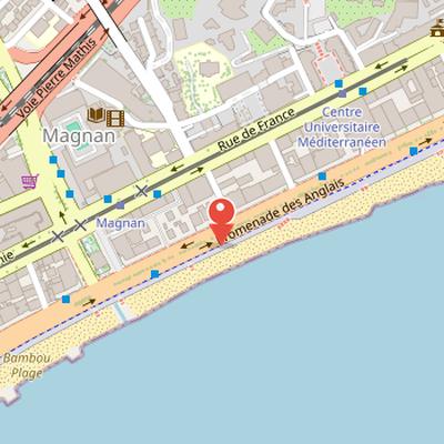
Nearby Objects
-
 Musée des Beaux-Arts Jules Chéret 400 m away
 -
 Église Saint-Pierre d'Arène 950 m away
 -

-
 Musée Masséna 1000 m away
 -
 Musée international d'art naïf Anatole Jakovsky 1300 m away
Seafront Avenue and Tourism Landmark
The Promenade des Anglais is an avenue along the seafront in Nice, facing the Baie des Anges. Its history is linked to the beginnings of international tourism, which gives it a notable place in the city's development. The avenue is lined by prestigious hotels, adding to its prominence as a coastal public space. It is also regarded as one of the most famous avenues in the world.
From Coastal Path to Urban Promenade
The Promenade des Anglais began as a modest earthen and stony path, two meters wide, known as the chemin des Anglais, linking the right bank of the Paillon to the Croix de Marbre suburb. According to Histoire, this first path was built between 1822 and 1824 by the local British wintering community, with funding attributed to Reverend . A later annexed document to the Consiglio d Ornato regulatory plan of 1843 proposed a coastal road from the mouth of the Paillon to the Magnan valley. On March 16, 1843, patents signed by King Charles-Albert of Sardinia granted the municipality free use of the coastline, and on July 29 the municipal council approved a project submitted by the city architect Antoine Scoffier, based on a route drawn since 1830.
Work began in 1844 from the south-east mouth corner of the Paillon to the Saint-Philippe valley, at an elevation of five meters above sea level. The planned road was twenty-three meters wide, although only twelve meters were executed at that stage. On March 31, 1858, the road was named Lungomare degli Inglesi and extended to Magnan following a project by the architect Francois Aune. Major works then widened the promenade by eleven meters to create a double row tree avenue. Further extensions followed: to Sainte-Helene on January 10, 1860, to Carras on March 17, 1871, and to Var on May 11, 1872. Over time, villas and gardens were gradually replaced by palaces, hotels, casinos, and residential buildings. Automobile traffic developed and created problems from the 1920s, and the municipality carried out major works between Opera and Boulevard Gambetta in 1931, shaping the current appearance of the promenade. The widening was extended from Boulevard Gambetta to Avenue Ferber in 1950.
Public Life and Seafront Design
The Promenade des Anglais, often called simply the Promenade or affectionately the Prom, is one of the must-visit places in Nice. It was listed as a UNESCO World Heritage site after the city created an AVAP and completed several years of renovation work. Today, it serves as a major public space for leisure, sport, and events. It is a meeting place for roller enthusiasts and is favored by jogging enthusiasts, helped by a nearly constant slight offshore breeze. A bike lane on the south sidewalk provides the fastest cycling route to cross the city from east to west, and the same sidewalk also features a stade de Pilou.
The promenade is also closely associated with public gatherings and seasonal festivities. It hosts numerous events, including the Nice carnival and flower battles. Its seafront design includes the Blue Chairs and pergolas intended for Mediterranean relaxation and views of the Bay of Angels. Near the Jardin, there is also a structure by Sabine Geraudie that replicates the Blue Chair.
Road Layout and Redevelopment
The Promenade des Anglais is structured by the Voie nord on the city side, running west, and the Voie sud on the sea side, running east. The Voie nord has three traffic lanes along almost its entire length, except for four lanes at the airport. The Voie sud was redeveloped and now has three lanes, with four lanes on rare sections. Parking was moved to the central sidewalk, and a dedicated bike lane was built on the sea side from the airport to Lenval.
Before 2007, the road layout was broader in several places: it was a six-lane highway at the airport, had five lanes between Haliotis and Lenval hospital, four lanes from Lenval to around Grosso / Gambetta, and three lanes extended to the end of the Voie sud. Ammenities recorded that approximately vehicles pass through the Promenade des Anglais daily. The Promenade des Anglais and Quai des Etats-Unis visually and collectively form a single homogeneous coastal artery. In 2012, environmental noise improvement works included acoustic pavement, which reduced traffic noise by up to 9 decibels.
Design Features of the Promenade
Urbanisme describes the Promenade des Anglais as an avenue with a slightly brown pavement running along eight kilometers of beach. Kiosks and pergolas line this stretch, and the avenue's urban furniture was specially designed. The street lamps are notable for lighting both the ground and the sky, and they also act as beacons for airplane approaches. On west wind days, airplanes follow these light paths in curved approaches aligned with the runways. This system helps aircraft avoid flying over Nice city, as they move low over the sea along the promenade before landing at the third largest airport in France.
Layout and Changing Seafront Features
The Promenade des Anglais shows a street layout shaped by its relationship to the city and the sea. Urbanisme notes that the numbering progresses continuously from east to west on the north side only, and later continues with odd numbers because of the terrain. This arrangement reflects the historical placement of the first palaces and villas, whose entrances were on the north side facing the city. Some entrances also face Rue de France, the road from Nice to the border with France. Urbanisme explains that Nice was then a winter resort known for its dry winter season, while the sea was not yet treated as a recreational area, so building entrances were oriented away from the promenade. The name Promenade des Anglais can also be read as suggesting that English people were the only ones who walked there, showing how the name itself has invited interpretation. Along the seafront, urban furniture changes over time, with chairs, benches, and pergolas regularly installed. The beaches are also marked by white porches named after private beaches to indicate their entrances. Urbanisme reports that the city hall of Nice reduced one lane of the south roadway between Haliotis and Grosso to create a bike lane, and that the Lido pier near Palais de la Mediterranee was demolished because it had become worn and dangerous. Its removal was also intended to harmonize the coastal area, even though it had been a visual landmark for locals along the seafront.
Speed Races on the Promenade des Anglais
During the Semaine de Nice, the Promenade des Anglais formed part of a wider series of automobile events that included speed races and tourism contests departing from Nice. The program also featured flower parades and elegance contests, as well as a hill climb race at La Turbie. On the cement of the Promenade des Anglais, standing start mile and flying kilometer races were held, making the seafront road a key setting for timed trials. In this context, a terrestrial speed record over one kilometer was recorded by Leon Serpollet driving Gardner-Serpollet. The record was set on an unspecified date, and it was broken multiple times at other locations. A later record reached a certain value on an unspecified date, and this new record was set within the Semaine de Nice event on the coastal road extending from the Promenade des Anglais.