Place Gabriel-Péri is a public square in Lyon, France, situated at the border of two districts and at the intersection of several major communication axes. It is commonly known locally as place du Pont, a name linked to its proximity to the Pont de la Guillotière. Historically, the square was better known by this earlier name because it provided access to the bridge. Until 1776, the Pont de la Guillotière was the only bridge over the Rhône, making the area a privileged passage for people entering Lyon from the left bank of the river, including arrivals from Italy or Dauphiné. The topography of the place was modified after 1820, following the destruction of the eastern arches of the bridge. It later became a lively urban space bordered by shops, breweries, the Grand Bazar, and other stores. The square was named Gabriel Péri by municipal deliberation, in reference to Gabriel Péri, a politician and French Resistance member during World War II.
Nearby Objects
-
 Bahadourian 200 m away
 -
 Centre nautique Tony-Bertrand 350 m away
 -
 Avenue de Saxe 450 m away
 -
 Place Guichard 550 m away
 -
 Rue de Marseille 550 m away
Location and Urban Role
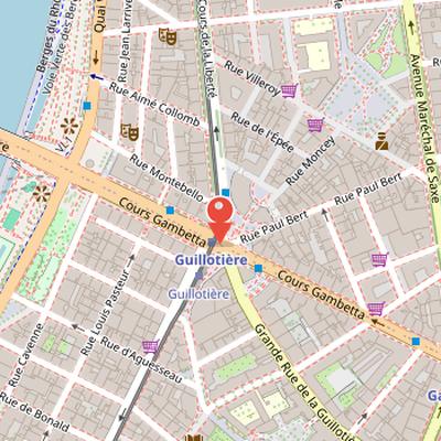
Place Gabriel-Peri is a public square in Lyon, France, located at the border of two districts. It is situated at the intersection of several major communication axes in the city. Locally, it is also called place du Pont because of its proximity to pont de la Guillotiere. This position gives the square a notable urban role as a point of connection within Lyon.
Place du Pont and the Commune fighting
Place Gabriel-Peri is better known as place du Pont, a name linked to its access to the pont de la Guillotiere in Lyon. The bridge was the only crossing over the Rhone until 1776, which made the place a privileged passage for people entering Lyon from the left bank of the Rhone, especially from Italy or Dauphine. Its topography changed from 1820, after the eastern arches of the pont de la Guillotiere were destroyed. Over time, the area became lively and was bordered by shops, breweries, the Grand Bazar, and other stores.
The place du Pont and the adjacent streets were also the scene of the last combats of the Commune de Lyon. Guards and Lyon inhabitants took the mairie de la Guillotiere at 6 place du Pont and built barricades on the Grand rue de la Guillotiere and cours des Brosses. The army arrived from Perrache on the orders of prefect Valentin. According to the account, the army twice refused to fire at the call of insurgents. Fighting began in the late afternoon and continued into the evening, with the army using artillery to break the doors of the mairie. About thirty deaths occurred in these combats, and the barricades held until the next morning, with many wounded and at least 13 dead.
Transport Hub and Naming
Place Gabriel-Peri was named by municipal deliberation in honor of Gabriel Peri, a politician and French resistance member during World War II. The place is located at the intersection of cours Gambetta, cours de la Liberte, rue de Marseille, grande rue de la Guillotiere, rue Paul-Bert, rue Moncey, and rue Marignan. It is also a transport node: the Guillotiere - Gabriel Peri metro station opened in 1991 under the place on metro line D, running east-west along cours Gambetta. Tramway line T1 passes north-south through the place, connecting cours de la Liberte and rue de Marseille, with a stop at Guillotiere - Gabriel Peri. In early 2009, the metro, tramway, and bus stops that had initially been named Guillotiere were renamed Guillotiere - Gabriel Peri.
Access and Public Transport
Gabriel-Peri is served by the Guillotiere - Gabriel Peri station of the TCL network. The station provides access to Lyon Metro line D and Lyon Tramway line T1. It is also served by the major bus lines C9 and C12, as well as the night bus line PL2 (Pleine Lune 2). This range of connections makes the site accessible through several forms of public transport.